Yavuzeli night lights from space
Night Light of Yavuzeli (Gaziantep) from space (Turkey) Src. Average luminocity for 10x10km area is 5.5325% and for 50x50km: 7.8908%.
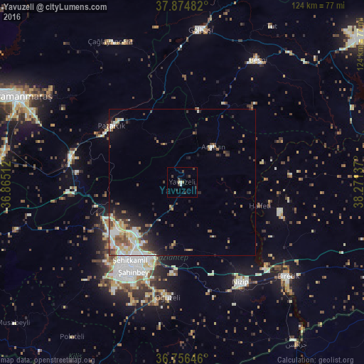
Analysis of Yavuzeli night lights 2016
Square area 10x10 km:
 0.32%
0.32%90-99
0.97%80-89
0.65%70-79
0%60-69
0.16%50-59
0.49%40-49
2.6%30-39
1.3%20-29
1.95%10-19
1.79%0-9
89.77%Square area 50x50 km:
0.89%90-99
2.04%80-89
0.93%70-79
0.86%60-69
0.93%50-59
0.91%40-49
1.51%30-39
1.31%20-29
1.63%10-19
2.93%0-9
86.07%Clear (daylight) street map image can be seen on geolist.org.
Map coordinates:
37° 52' 29.4" North, 36° 51' 54.4" East
37° 19' 3.8" North, 37° 34' 5.7" East
36° 45' 23.3" North, 38° 16' 16.9" East
Some cities around Yavuzeli sort by population:
• Gaziantep
33.1 km =20.6 mi,  209°
209°
• Nizip
39.7 km =24.7 mi,  149°
149°
• Birecik
48.7 km =30.3 mi,  131°
131°
• Besni
49.1 km =30.5 mi,  31°
31°
• Gölbaşı
52.2 km =32.4 mi,  6°
6°
• Pazarcık
30.3 km =18.8 mi,  308°
308°
• Oğuzeli
39.4 km =24.5 mi,  187°
187°
• Araban
16.1 km =10 mi,  41°
41°
297532 (p: 8,170)
Sources (retrieved 2019-11-25):
» Earth at Night: Flat Maps 2012, 2016