Araban night lights from space
Night Light of Araban (Gaziantep) from space (Turkey) Src. Average luminocity for 10x10km area is 7.513% and for 50x50km: 2.9764%.
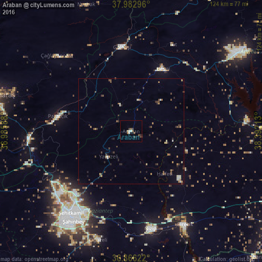
Analysis of Araban night lights 2016
Square area 10x10 km:
 0.81%
0.81%90-99
1.14%80-89
0.65%70-79
0%60-69
1.14%50-59
1.62%40-49
2.44%30-39
1.3%20-29
0.65%10-19
2.11%0-9
88.15%Square area 50x50 km:
0.1%90-99
0.42%80-89
0.29%70-79
0.33%60-69
0.27%50-59
0.38%40-49
1.07%30-39
0.86%20-29
0.53%10-19
0.61%0-9
95.14%Clear (daylight) street map image can be seen on geolist.org.
Map coordinates:
37° 58' 58.7" North, 36° 59' 9.2" East
37° 25' 36" North, 37° 41' 20.4" East
36° 51' 58.4" North, 38° 23' 31.7" East
Some cities around Araban sort by population:
• Gaziantep
49 km =30.4 mi,  213°
213°
• Nizip
47.3 km =29.4 mi,  168°
168°
• Besni
33.3 km =20.7 mi,  27°
27°
• Gölbaşı
40 km =24.9 mi,  353°
353°
• Pazarcık
35 km =21.7 mi,  281°
281°
• Çağlayancerit
50.1 km =31.1 mi,  314°
314°
• Yavuzeli
16.1 km =10 mi,  221°
221°
• Tut
45.6 km =28.3 mi, 26°
323750 (p: 11,128)
Sources (retrieved 2019-11-25):
» Earth at Night: Flat Maps 2012, 2016