Selendi night lights from space
Night Light of Selendi (Manisa) from space (Turkey) Src. Average luminocity for 10x10km area is 9.3605% and for 50x50km: 2.3742%.
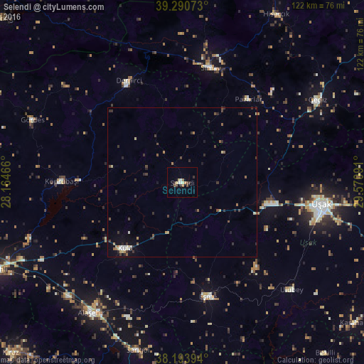
Analysis of Selendi night lights 2016
Square area 10x10 km:
100  1.36%
1.36%
90-99 0.68%
80-89 1.87%
70-79 1.36%
60-69 0.68%
50-59 0.85%
40-49 1.7%
30-39 3.06%
20-29 0%
10-19 0.51%
0-9 87.93%
1.36%90-99
0.68%80-89
1.87%70-79
1.36%60-69
0.68%50-59
0.85%40-49
1.7%30-39
3.06%20-29
0%10-19
0.51%0-9
87.93%Square area 50x50 km:
100 0.15%
90-99 0.24%
80-89 0.3%
70-79 0.23%
60-69 0.25%
50-59 0.36%
40-49 0.43%
30-39 0.8%
20-29 0.77%
10-19 0.88%
0-9 95.6%
0.15%90-99
0.24%80-89
0.3%70-79
0.23%60-69
0.25%50-59
0.36%40-49
0.43%30-39
0.8%20-29
0.77%10-19
0.88%0-9
95.6%Clear (daylight) street map image can be seen on geolist.org.
Map coordinates:
39° 17' 26.6" North, 28° 9' 52.8" East
38° 44' 40" North, 28° 52' 4" East
38° 11' 38.2" North, 29° 34' 15.3" East
Some cities around Selendi sort by population:
• Uşak
47.3 km =29.4 mi,  99°
99°
• Simav
39.4 km =24.5 mi,  13°
13°
• Kula
29 km =18 mi,  220°
220°
• Demirci
38.1 km =23.7 mi,  331°
331°
• Eşme
39.3 km =24.4 mi,  167°
167°
• Pazarlar
35.7 km =22.2 mi,  38°
38°
• Ulubey
51.6 km =32.1 mi,  134°
134°
• Şaphane
43.9 km =27.3 mi, 44°
301251 (p: 8,735)
Sources (retrieved 2019-11-25):
» Earth at Night: Flat Maps 2012, 2016