Pazarlar night lights from space
Night Light of Pazarlar (Kütahya) from space (Turkey) Src. Average luminocity for 10x10km area is 8.8442% and for 50x50km: 4.128%.
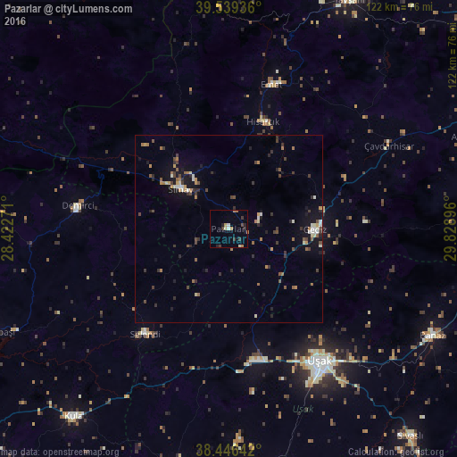
Analysis of Pazarlar night lights 2016
Square area 10x10 km:
100  0.16%
0.16%
90-99 1.46%
80-89 0.97%
70-79 0.81%
60-69 2.76%
50-59 0%
40-49 0.65%
30-39 3.73%
20-29 1.62%
10-19 1.14%
0-9 86.69%
0.16%90-99
1.46%80-89
0.97%70-79
0.81%60-69
2.76%50-59
0%40-49
0.65%30-39
3.73%20-29
1.62%10-19
1.14%0-9
86.69%Square area 50x50 km:
100 0.09%
90-99 0.65%
80-89 0.3%
70-79 0.49%
60-69 0.77%
50-59 0.43%
40-49 0.79%
30-39 1.12%
20-29 0.83%
10-19 2.45%
0-9 92.06%
0.09%90-99
0.65%80-89
0.3%70-79
0.49%60-69
0.77%50-59
0.43%40-49
0.79%30-39
1.12%20-29
0.83%10-19
2.45%0-9
92.06%Clear (daylight) street map image can be seen on geolist.org.
Map coordinates:
39° 32' 21.7" North, 28° 25' 21.8" East
38° 59' 42" North, 29° 7' 33" East
38° 26' 47.1" North, 29° 49' 44.3" East
Some cities around Pazarlar sort by population:
• Uşak
43.2 km =26.8 mi,  145°
145°
• Simav
16.5 km =10.3 mi,  309°
309°
• Emet
40.3 km =25 mi,  16°
16°
• Gediz
22.9 km =14.2 mi,  90°
90°
• Demirci
40.7 km =25.3 mi,  278°
278°
• Banaz
61.3 km =38.1 mi,  117°
117°
• Selendi
35.7 km =22.2 mi,  218°
218°
• Şaphane
9.1 km =5.7 mi,  66°
66°
302787 (p: 6,387)
Sources (retrieved 2019-11-25):
» Earth at Night: Flat Maps 2012, 2016