Pertek night lights from space
Night Light of Pertek (Tunceli) from space (Turkey) Src. Average luminocity for 10x10km area is 12.6752% and for 50x50km: 6.575%.
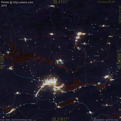
Analysis of Pertek night lights 2016
Square area 10x10 km:
100  0.68%
0.68%
90-99 1.02%
80-89 2.38%
70-79 3.23%
60-69 1.87%
50-59 2.04%
40-49 1.87%
30-39 1.87%
20-29 0%
10-19 1.19%
0-9 83.84%
0.68%90-99
1.02%80-89
2.38%70-79
3.23%60-69
1.87%50-59
2.04%40-49
1.87%30-39
1.87%20-29
0%10-19
1.19%0-9
83.84%Square area 50x50 km:
100 0.93%
90-99 1.42%
80-89 0.74%
70-79 0.78%
60-69 0.68%
50-59 0.6%
40-49 0.83%
30-39 1.14%
20-29 1.77%
10-19 3.78%
0-9 87.33%
0.93%90-99
1.42%80-89
0.74%70-79
0.78%60-69
0.68%50-59
0.6%40-49
0.83%30-39
1.14%20-29
1.77%10-19
3.78%0-9
87.33%Clear (daylight) street map image can be seen on geolist.org.
Map coordinates:
39° 24' 40" North, 38° 37' 10.6" East
38° 51' 56.7" North, 39° 19' 21.8" East
38° 18' 58.2" North, 40° 1' 33.1" East
Some cities around Pertek sort by population:
• Elazığ
23 km =14.3 mi,  202°
202°
• Tunceli
32.2 km =20 mi,  36°
36°
• Kovancılar
49.6 km =30.8 mi,  109°
109°
• Baskil
55 km =34.2 mi,  233°
233°
• Palu
55.3 km =34.4 mi, 110°
• Hozat
27.9 km =17.3 mi,  339°
339°
• Keban
51.5 km =32 mi,  261°
261°
• Sivrice
47.1 km =29.3 mi,  181°
181°
302724 (p: 6,837)
Sources (retrieved 2019-11-25):
» Earth at Night: Flat Maps 2012, 2016