Sivrice night lights from space
Night Light of Sivrice (Elazığ) from space (Turkey) Src. Average luminocity for 10x10km area is 6.1932% and for 50x50km: 6.6684%.
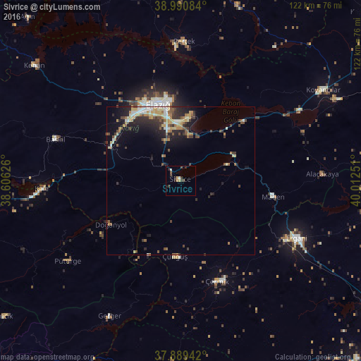
Analysis of Sivrice night lights 2016
Square area 10x10 km:
 0%
0%90-99
1.3%80-89
0.32%70-79
0.97%60-69
0.65%50-59
0%40-49
3.08%30-39
1.95%20-29
2.11%10-19
0%0-9
89.61%Square area 50x50 km:
0.4%90-99
1.13%80-89
1.03%70-79
1.12%60-69
0.79%50-59
0.87%40-49
1.06%30-39
1.34%20-29
2.13%10-19
3.43%0-9
86.71%Clear (daylight) street map image can be seen on geolist.org.
Map coordinates:
38° 59' 27" North, 38° 36' 22.5" East
38° 26' 32" North, 39° 18' 33.8" East
37° 53' 21.9" North, 40° 0' 45" East
Some cities around Sivrice sort by population:
• Elazığ
26.9 km =16.7 mi,  343°
343°
• Ergani
43.3 km =26.9 mi,  116°
116°
• Kovancılar
57.1 km =35.5 mi,  57°
57°
• Çermik
36.1 km =22.4 mi,  160°
160°
• Baskil
45.1 km =28 mi,  288°
288°
• Pertek
47.1 km =29.3 mi,  1°
1°
• Doğanyol
28.3 km =17.6 mi,  237°
237°
• Çüngüş
26.1 km =16.2 mi,  184°
184°
300601 (p: 5,481)
Sources (retrieved 2019-11-25):
» Earth at Night: Flat Maps 2012, 2016