Keban night lights from space
Night Light of Keban (Elazığ) from space (Turkey) Src. Average luminocity for 10x10km area is 6.2466% and for 50x50km: 0.8599%.
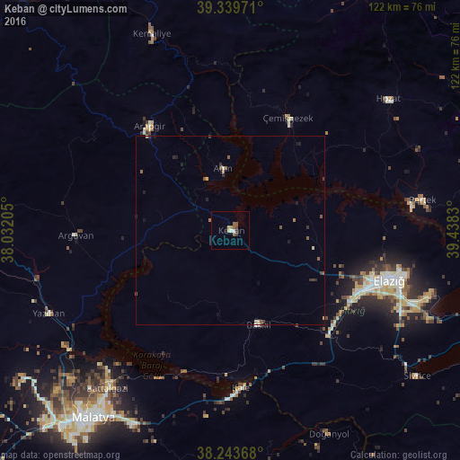
Analysis of Keban night lights 2016
Square area 10x10 km:
100  0.34%
0.34%
90-99 1.02%
80-89 0.68%
70-79 0.68%
60-69 1.36%
50-59 1.36%
40-49 1.53%
30-39 1.19%
20-29 0%
10-19 0%
0-9 91.84%
0.34%90-99
1.02%80-89
0.68%70-79
0.68%60-69
1.36%50-59
1.36%40-49
1.53%30-39
1.19%20-29
0%10-19
0%0-9
91.84%Square area 50x50 km:
100 0.01%
90-99 0.09%
80-89 0.14%
70-79 0.03%
60-69 0.11%
50-59 0.3%
40-49 0.16%
30-39 0.22%
20-29 0.14%
10-19 0.26%
0-9 98.54%
0.01%90-99
0.09%80-89
0.14%70-79
0.03%60-69
0.11%50-59
0.3%40-49
0.16%30-39
0.22%20-29
0.14%10-19
0.26%0-9
98.54%Clear (daylight) street map image can be seen on geolist.org.
Map coordinates:
39° 20' 23" North, 38° 1' 55.4" East
38° 47' 37.7" North, 38° 44' 6.6" East
38° 14' 37.2" North, 39° 26' 17.9" East
Some cities around Keban sort by population:
• Malatya
61.3 km =38.1 mi,  216°
216°
• Elazığ
44.4 km =27.6 mi,  107°
107°
• Baskil
26 km =16.2 mi,  164°
164°
• Arapgir
34.5 km =21.4 mi,  322°
322°
• Hozat
53.2 km =33.1 mi,  50°
50°
• Pertek
51.5 km =32 mi,  81°
81°
• Doğanyol
60 km =37.3 mi,  154°
154°
• Yazıhan
53.6 km =33.3 mi,  245°
245°
308389 (p: 5,837)
Sources (retrieved 2019-11-25):
» Earth at Night: Flat Maps 2012, 2016