Osmaneli night lights from space
Night Light of Osmaneli (Bilecik) from space (Turkey) Src. Average luminocity for 10x10km area is 12.9898% and for 50x50km: 5.0765%.
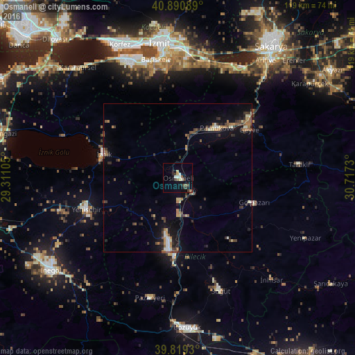
Analysis of Osmaneli night lights 2016
Square area 10x10 km:
 1.36%
1.36%90-99
2.04%80-89
1.36%70-79
0.68%60-69
0.34%50-59
3.06%40-49
2.04%30-39
3.23%20-29
1.87%10-19
4.76%0-9
79.25%Square area 50x50 km:
0.36%90-99
0.53%80-89
0.57%70-79
0.49%60-69
0.7%50-59
1.01%40-49
0.71%30-39
1.29%20-29
1.09%10-19
3.01%0-9
90.25%Clear (daylight) street map image can be seen on geolist.org.
Map coordinates:
40° 53' 27.2" North, 29° 18' 39.8" East
40° 21' 26" North, 30° 0' 51" East
39° 49' 9.5" North, 30° 43' 2.3" East
Some cities around Osmaneli sort by population:
• Bilecik
24.1 km =15 mi,  187°
187°
• Yenişehir
32.3 km =20.1 mi,  251°
251°
• İznik
26.1 km =16.2 mi,  287°
287°
• Geyve
28.9 km =18 mi,  54°
54°
• Pamukova
21.2 km =13.2 mi,  37°
37°
• Bahçecik
35.6 km =22.1 mi,  346°
346°
• Gölpazarı
26.9 km =16.7 mi,  107°
107°
• Yuvacık
37 km =23 mi, 353°
740881 (p: 15,708)
Sources (retrieved 2019-11-25):
» Earth at Night: Flat Maps 2012, 2016