Gölpazarı night lights from space
Night Light of Gölpazarı (Bilecik) from space (Turkey) Src. Average luminocity for 10x10km area is 4.9252% and for 50x50km: 2.5589%.
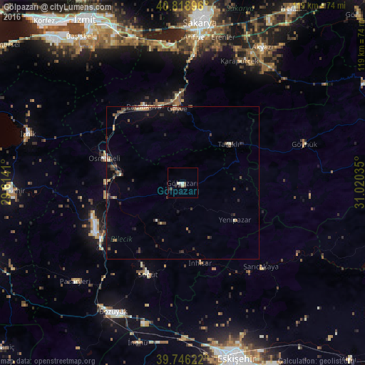
Analysis of Gölpazarı night lights 2016
Square area 10x10 km:
 0.68%
0.68%90-99
1.53%80-89
0.51%70-79
0%60-69
0%50-59
0.68%40-49
0.68%30-39
1.7%20-29
1.19%10-19
0%0-9
93.03%Square area 50x50 km:
0.06%90-99
0.28%80-89
0.3%70-79
0.14%60-69
0.3%50-59
0.54%40-49
0.5%30-39
0.82%20-29
0.62%10-19
1.18%0-9
95.26%Clear (daylight) street map image can be seen on geolist.org.
Map coordinates:
40° 49' 8.3" North, 29° 36' 50.8" East
40° 17' 5" North, 30° 19' 2" East
39° 44' 46.4" North, 31° 1' 13.3" East
Some cities around Gölpazarı sort by population:
• Bilecik
32.8 km =20.4 mi,  241°
241°
• Sapanca
45.4 km =28.2 mi,  354°
354°
• Geyve
24.9 km =15.5 mi,  355°
355°
• Osmaneli
26.9 km =16.7 mi,  287°
287°
• Pamukova
27.9 km =17.3 mi,  332°
332°
• Mihalgazi
36.2 km =22.5 mi,  142°
142°
• Pazaryeri
47.7 km =29.6 mi,  227°
227°
• Göynük
41.9 km =26 mi,  72°
72°
746602 (p: 7,406)
Sources (retrieved 2019-11-25):
» Earth at Night: Flat Maps 2012, 2016