Kepsut night lights from space
Night Light of Kepsut (Balıkesir) from space (Turkey) Src. Average luminocity for 10x10km area is 9.7646% and for 50x50km: 7.5396%.
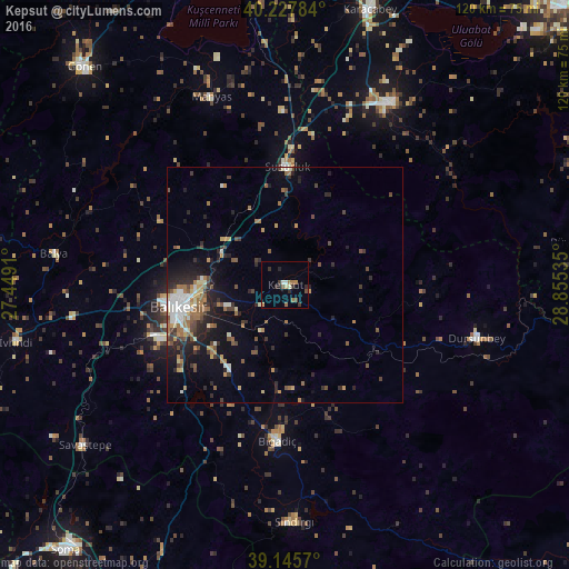
Analysis of Kepsut night lights 2016
Square area 10x10 km:
 0.81%
0.81%90-99
1.14%80-89
0.65%70-79
0.97%60-69
2.27%50-59
1.14%40-49
1.46%30-39
2.76%20-29
3.08%10-19
0%0-9
85.71%Square area 50x50 km:
0.71%90-99
1.14%80-89
0.56%70-79
0.82%60-69
1.58%50-59
1.08%40-49
1.2%30-39
1.26%20-29
2.51%10-19
3.85%0-9
85.29%Clear (daylight) street map image can be seen on geolist.org.
Map coordinates:
40° 13' 40.2" North, 27° 26' 56.8" East
39° 41' 20" North, 28° 9' 8" East
39° 8' 44.5" North, 28° 51' 19.3" East
Some cities around Kepsut sort by population:
• Balıkesir
23.2 km =14.4 mi,  259°
259°
• Mustafakemalpaşa
44.6 km =27.7 mi,  29°
29°
• Susurluk
25 km =15.5 mi,  1°
1°
• Dursunbey
42.1 km =26.2 mi,  105°
105°
• Bigadiç
33 km =20.5 mi,  183°
183°
• Sındırgı
49.8 km =30.9 mi, 177°
• Savaştepe
54.5 km =33.9 mi,  231°
231°
• Manyas
42.7 km =26.5 mi,  338°
338°
308133 (p: 5,542)
Sources (retrieved 2019-11-25):
» Earth at Night: Flat Maps 2012, 2016