Dursunbey night lights from space
Night Light of Dursunbey (Balıkesir) from space (Turkey) Src. Average luminocity for 10x10km area is 10.3425% and for 50x50km: 1.224%.
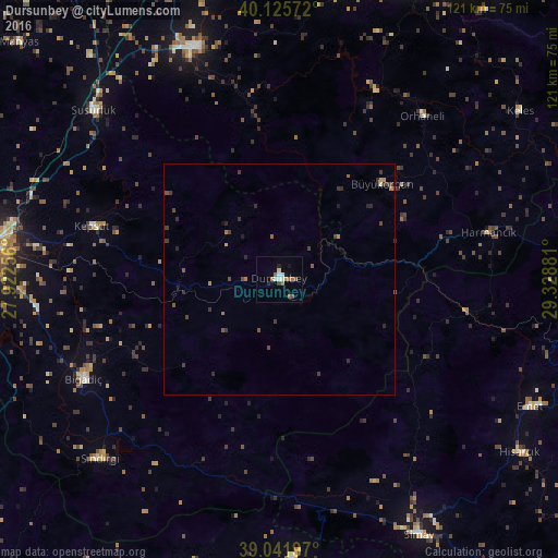
Analysis of Dursunbey night lights 2016
Square area 10x10 km:
 0.97%
0.97%90-99
2.27%80-89
0.65%70-79
0.81%60-69
2.44%50-59
1.95%40-49
0.81%30-39
0.49%20-29
1.14%10-19
1.95%0-9
86.53%Square area 50x50 km:
0.04%90-99
0.12%80-89
0.03%70-79
0.17%60-69
0.2%50-59
0.27%40-49
0.29%30-39
0.46%20-29
0.42%10-19
0.21%0-9
97.8%Clear (daylight) street map image can be seen on geolist.org.
Map coordinates:
40° 7' 32.6" North, 27° 55' 21.2" East
39° 35' 9.5" North, 28° 37' 32.4" East
39° 2' 31.1" North, 29° 19' 43.7" East
Some cities around Dursunbey sort by population:
• Mustafakemalpaşa
53.6 km =33.3 mi,  339°
339°
• Susurluk
54.1 km =33.6 mi,  312°
312°
• Emet
60.7 km =37.7 mi,  116°
116°
• Demirci
60.1 km =37.3 mi,  177°
177°
• Bigadiç
47.6 km =29.6 mi,  243°
243°
• Sındırgı
54.3 km =33.7 mi,  225°
225°
• Orhaneli
47.1 km =29.3 mi,  41°
41°
• Kepsut
42.1 km =26.2 mi,  285°
285°
316102 (p: 17,532)
Sources (retrieved 2019-11-25):
» Earth at Night: Flat Maps 2012, 2016