Bigadiç night lights from space
Night Light of Bigadiç (Balıkesir) from space (Turkey) Src. Average luminocity for 10x10km area is 17.5663% and for 50x50km: 5.1217%.
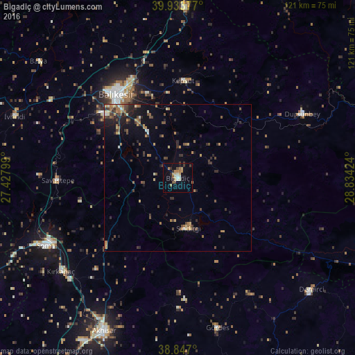
Analysis of Bigadiç night lights 2016
Square area 10x10 km:
 0.34%
0.34%90-99
2.38%80-89
3.4%70-79
2.38%60-69
4.25%50-59
1.02%40-49
2.04%30-39
2.21%20-29
2.55%10-19
8.84%0-9
70.58%Square area 50x50 km:
0.04%90-99
0.48%80-89
0.59%70-79
0.77%60-69
1.02%50-59
0.71%40-49
1.11%30-39
1.15%20-29
1.56%10-19
2.45%0-9
90.11%Clear (daylight) street map image can be seen on geolist.org.
Map coordinates:
39° 56' 1.6" North, 27° 25' 40.8" East
39° 23' 33" North, 28° 7' 52" East
38° 50' 49.2" North, 28° 50' 3.3" East
Some cities around Bigadiç sort by population:
• Balıkesir
35.4 km =22 mi,  323°
323°
• Soma
50.4 km =31.3 mi,  242°
242°
• Kırkağaç
50.9 km =31.6 mi,  231°
231°
• Dursunbey
47.6 km =29.6 mi,  63°
63°
• Gördes
52.9 km =32.9 mi,  165°
165°
• Sındırgı
17.3 km =10.7 mi, 166°
• Savaştepe
40.8 km =25.4 mi,  268°
268°
• Kepsut
33 km =20.5 mi,  3°
3°
321136 (p: 15,242)
Sources (retrieved 2019-11-25):
» Earth at Night: Flat Maps 2012, 2016