Manyas night lights from space
Night Light of Manyas (Balıkesir) from space (Turkey) Src. Average luminocity for 10x10km area is 12.3604% and for 50x50km: 4.659%.
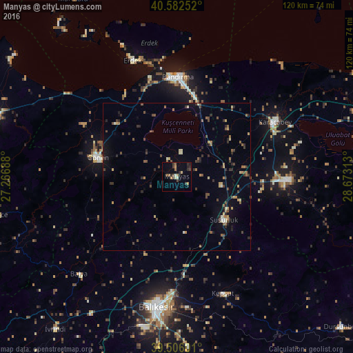
Analysis of Manyas night lights 2016
Square area 10x10 km:
 0.16%
0.16%90-99
1.14%80-89
1.3%70-79
1.46%60-69
3.25%50-59
0.81%40-49
2.76%30-39
2.27%20-29
5.19%10-19
0.81%0-9
80.84%Square area 50x50 km:
0.03%90-99
0.33%80-89
0.59%70-79
0.46%60-69
0.89%50-59
0.76%40-49
1.08%30-39
1%20-29
1.32%10-19
1.28%0-9
92.25%Clear (daylight) street map image can be seen on geolist.org.
Map coordinates:
40° 34' 57.1" North, 27° 16' 0.8" East
40° 2' 47" North, 27° 58' 12" East
39° 30' 21.6" North, 28° 40' 23.3" East
Some cities around Manyas sort by population:
• Balıkesir
44.7 km =27.8 mi,  189°
189°
• Bandırma
34 km =21.1 mi,  0°
0°
• Mustafakemalpaşa
37.4 km =23.2 mi,  91°
91°
• Karacabey
38.1 km =23.7 mi,  60°
60°
• Gönen
27.7 km =17.2 mi,  283°
283°
• Susurluk
21.8 km =13.5 mi,  132°
132°
• Erdek
42 km =26.1 mi,  339°
339°
• Kepsut
42.7 km =26.5 mi,  158°
158°
741737 (p: 5,327)
Sources (retrieved 2019-11-25):
» Earth at Night: Flat Maps 2012, 2016