Savaştepe night lights from space
Night Light of Savaştepe (Balıkesir) from space (Turkey) Src. Average luminocity for 10x10km area is 6.1412% and for 50x50km: 5.7505%.
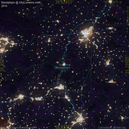
Analysis of Savaştepe night lights 2016
Square area 10x10 km:
 0.85%
0.85%90-99
0.51%80-89
0.34%70-79
0.34%60-69
2.38%50-59
1.02%40-49
0.34%30-39
1.19%20-29
0.85%10-19
0%0-9
92.18%Square area 50x50 km:
0.31%90-99
0.91%80-89
0.67%70-79
0.55%60-69
0.72%50-59
0.67%40-49
1.22%30-39
1.25%20-29
1.56%10-19
3.89%0-9
88.23%Clear (daylight) street map image can be seen on geolist.org.
Map coordinates:
39° 55' 28.3" North, 26° 57' 10.8" East
39° 22' 59.5" North, 27° 39' 22" East
38° 50' 15.4" North, 28° 21' 33.3" East
Some cities around Savaştepe sort by population:
• Balıkesir
35.6 km =22.1 mi,  33°
33°
• Soma
22.3 km =13.9 mi,  190°
190°
• Bergama
50.3 km =31.3 mi,  234°
234°
• Kırkağaç
30.8 km =19.1 mi,  177°
177°
• Bigadiç
40.8 km =25.4 mi,  88°
88°
• Sındırgı
47.6 km =29.6 mi,  109°
109°
• Kınık
40.4 km =25.1 mi,  215°
215°
• İvrindi
26.6 km =16.5 mi,  326°
326°
301453 (p: 10,324)
Sources (retrieved 2019-11-25):
» Earth at Night: Flat Maps 2012, 2016