Doğanyol night lights from space
Night Light of Doğanyol (Malatya) from space (Turkey) Src. Average luminocity for 10x10km area is 3.6037% and for 50x50km: 1.688%.
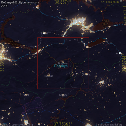
Analysis of Doğanyol night lights 2016
Square area 10x10 km:
 0%
0%90-99
0%80-89
0.17%70-79
0.85%60-69
0.34%50-59
1.19%40-49
2.04%30-39
0.17%20-29
1.36%10-19
1.02%0-9
92.86%Square area 50x50 km:
0.01%90-99
0.18%80-89
0.14%70-79
0.3%60-69
0.29%50-59
0.27%40-49
0.48%30-39
0.36%20-29
0.44%10-19
0.35%0-9
97.18%Clear (daylight) street map image can be seen on geolist.org.
Map coordinates:
38° 51' 25.6" North, 38° 19' 52.3" East
38° 18' 26.9" North, 39° 2' 3.5" East
37° 45' 13.1" North, 39° 44' 14.8" East
Some cities around Doğanyol sort by population:
• Malatya
62.8 km =39 mi,  274°
274°
• Elazığ
44 km =27.3 mi,  21°
21°
• Çermik
40.7 km =25.3 mi,  118°
118°
• Baskil
34.7 km =21.6 mi,  326°
326°
• Sincik
47.6 km =29.6 mi,  230°
230°
• Keban
60 km =37.3 mi, 334°
• Sivrice
28.3 km =17.6 mi,  57°
57°
• Çüngüş
24.6 km =15.3 mi, 116°
316431 (p: 6,332)
Sources (retrieved 2019-11-25):
» Earth at Night: Flat Maps 2012, 2016