Yazıhan night lights from space
Night Light of Yazıhan (Malatya) from space (Turkey) Src. Average luminocity for 10x10km area is 4.7078% and for 50x50km: 6.8025%.
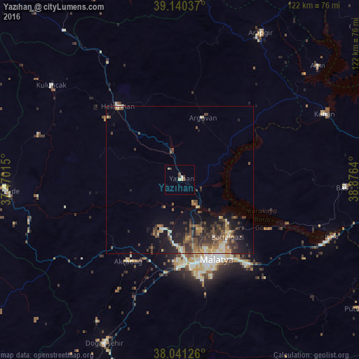
Analysis of Yazıhan night lights 2016
Square area 10x10 km:
 0%
0%90-99
0.81%80-89
1.79%70-79
0%60-69
0.16%50-59
0.49%40-49
1.95%30-39
0.65%20-29
0%10-19
0.32%0-9
93.83%Square area 50x50 km:
0.11%90-99
0.91%80-89
0.85%70-79
0.95%60-69
0.79%50-59
1.38%40-49
1.72%30-39
1.95%20-29
2.26%10-19
4.44%0-9
84.64%Clear (daylight) street map image can be seen on geolist.org.
Map coordinates:
39° 8' 25.3" North, 37° 28' 12.5" East
38° 35' 34.5" North, 38° 10' 23.8" East
38° 2' 28.5" North, 38° 52' 35" East
Some cities around Yazıhan sort by population:
• Malatya
29.7 km =18.5 mi,  155°
155°
• Baskil
56 km =34.8 mi,  92°
92°
• Akçadağ
33.3 km =20.7 mi,  212°
212°
• Hekimhan
32.7 km =20.3 mi,  319°
319°
• Yeşilyurt
33.6 km =20.9 mi,  169°
169°
• Kuluncak
54.4 km =33.8 mi,  305°
305°
• Keban
53.6 km =33.3 mi,  65°
65°
• Kale
51.2 km =31.8 mi,  342°
342°
297371 (p: 5,156)
Sources (retrieved 2019-11-25):
» Earth at Night: Flat Maps 2012, 2016