Havran night lights from space
Night Light of Havran (Balıkesir) from space (Turkey) Src. Average luminocity for 10x10km area is 22.5893% and for 50x50km: 8.7745%.
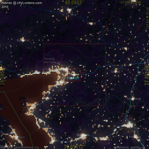
Analysis of Havran night lights 2016
Square area 10x10 km:
 0.49%
0.49%90-99
4.06%80-89
2.6%70-79
1.62%60-69
3.73%50-59
3.57%40-49
3.73%30-39
3.08%20-29
6.82%10-19
29.71%0-9
40.58%Square area 50x50 km:
0.51%90-99
1.58%80-89
1.09%70-79
0.87%60-69
1.56%50-59
0.85%40-49
1.19%30-39
1.46%20-29
3.26%10-19
8.19%0-9
79.43%Clear (daylight) street map image can be seen on geolist.org.
Map coordinates:
40° 5' 53.9" North, 26° 23' 42.8" East
39° 33' 30" North, 27° 5' 54" East
39° 0' 50.8" North, 27° 48' 5.3" East
Some cities around Havran sort by population:
• Ayvalık
43.8 km =27.2 mi,  232°
232°
• Bergama
49.2 km =30.6 mi,  171°
171°
• Edremit
7.6 km =4.7 mi,  303°
303°
• Burhaniye
12.6 km =7.8 mi,  239°
239°
• Çan
53 km =32.9 mi,  355°
355°
• Altınoluk
31 km =19.3 mi,  274°
274°
• Savaştepe
51.7 km =32.1 mi,  112°
112°
• İvrindi
33.4 km =20.8 mi,  85°
85°
312355 (p: 11,050)
Sources (retrieved 2019-11-25):
» Earth at Night: Flat Maps 2012, 2016