İvrindi night lights from space
Night Light of İvrindi (Balıkesir) from space (Turkey) Src. Average luminocity for 10x10km area is 10.4675% and for 50x50km: 2.9683%.
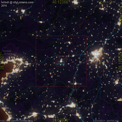
Analysis of İvrindi night lights 2016
Square area 10x10 km:
 0.49%
0.49%90-99
1.46%80-89
2.27%70-79
2.11%60-69
0.32%50-59
1.46%40-49
0.81%30-39
2.11%20-29
1.79%10-19
0.81%0-9
86.36%Square area 50x50 km:
0.05%90-99
0.22%80-89
0.33%70-79
0.42%60-69
0.58%50-59
0.51%40-49
0.59%30-39
0.86%20-29
0.79%10-19
0.49%0-9
95.16%Clear (daylight) street map image can be seen on geolist.org.
Map coordinates:
40° 7' 25.2" North, 26° 46' 59.8" East
39° 35' 2" North, 27° 29' 11" East
39° 2' 23.6" North, 28° 11' 22.3" East
Some cities around İvrindi sort by population:
• Balıkesir
35 km =21.7 mi,  78°
78°
• Soma
45.5 km =28.3 mi,  166°
166°
• Edremit
39.6 km =24.6 mi,  271°
271°
• Burhaniye
45 km =28 mi,  258°
258°
• Kırkağaç
55.4 km =34.4 mi,  163°
163°
• Havran
33.4 km =20.8 mi, 265°
• Kınık
55.9 km =34.7 mi,  189°
189°
• Savaştepe
26.6 km =16.5 mi,  146°
146°
311054 (p: 6,119)
Sources (retrieved 2019-11-25):
» Earth at Night: Flat Maps 2012, 2016