Altınoluk night lights from space
Night Light of Altınoluk (Balıkesir) from space (Turkey) Src. Average luminocity for 10x10km area is 18.8182% and for 50x50km: 8.8034%.
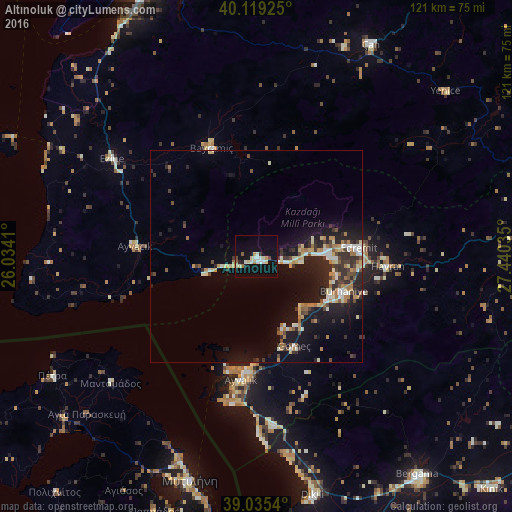
Analysis of Altınoluk night lights 2016
Square area 10x10 km:
 1.62%
1.62%90-99
4.87%80-89
2.6%70-79
1.46%60-69
1.79%50-59
1.3%40-49
1.3%30-39
0.65%20-29
1.3%10-19
21.92%0-9
61.2%Square area 50x50 km:
0.58%90-99
1.63%80-89
1.07%70-79
0.95%60-69
1.42%50-59
0.68%40-49
1.06%30-39
1.44%20-29
2.96%10-19
8%0-9
80.22%Clear (daylight) street map image can be seen on geolist.org.
Map coordinates:
40° 7' 9.3" North, 26° 2' 2.8" East
39° 34' 46" North, 26° 44' 14" East
39° 2' 7.4" North, 27° 26' 25.3" East
Some cities around Altınoluk sort by population:
• Ayvalık
29.2 km =18.1 mi,  187°
187°
• Edremit
24.7 km =15.3 mi,  85°
85°
• Burhaniye
22 km =13.7 mi,  113°
113°
• Mytilene, GR
54.7 km =34 mi,  196°
196°
• Çan
57.2 km =35.5 mi,  28°
28°
• Ezine
40.9 km =25.4 mi,  304°
304°
• Havran
31 km =19.3 mi, 94°
• Ayvacık
28.6 km =17.8 mi,  274°
274°
323911 (p: 13,800)
Sources (retrieved 2019-11-25):
» Earth at Night: Flat Maps 2012, 2016