Kale night lights from space
Night Light of Kale (Denizli) from space (Turkey) Src. Average luminocity for 10x10km area is 8.5032% and for 50x50km: 3.8827%.
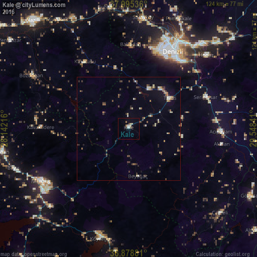
Analysis of Kale night lights 2016
Square area 10x10 km:
 1.14%
1.14%90-99
2.11%80-89
1.3%70-79
0%60-69
1.3%50-59
0.32%40-49
0.97%30-39
0.65%20-29
0.65%10-19
0.65%0-9
90.91%Square area 50x50 km:
0.12%90-99
0.67%80-89
0.48%70-79
0.28%60-69
0.39%50-59
0.55%40-49
0.66%30-39
1.1%20-29
0.87%10-19
0.88%0-9
93.99%Clear (daylight) street map image can be seen on geolist.org.
Map coordinates:
37° 59' 43.3" North, 28° 8' 31.8" East
37° 26' 21" North, 28° 50' 43" East
36° 52' 43.7" North, 29° 32' 54.3" East
Some cities around Kale sort by population:
• Denizli
42.9 km =26.7 mi,  29°
29°
• Merkezefendi
44.3 km =27.5 mi,  23°
23°
• Muğla
49 km =30.4 mi,  239°
239°
• Serinhisar
40.4 km =25.1 mi,  66°
66°
• Tavas
24.9 km =15.5 mi,  53°
53°
• Acıpayam
44.5 km =27.7 mi,  92°
92°
• Karacasu
38.4 km =23.9 mi,  326°
326°
• Nikfer
26.1 km =16.2 mi,  98°
98°
310789 (p: 7,255)
Sources (retrieved 2019-11-25):
» Earth at Night: Flat Maps 2012, 2016