Ouardenine night lights from space
Night Light of Ouardenine (Al Munastīr) from space (Tunisia) Src. Average luminocity for 10x10km area is 28.1171% and for 50x50km: 18.3614%.
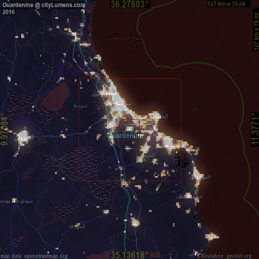
Analysis of Ouardenine night lights 2016
Square area 10x10 km:
 3.15%
3.15%90-99
2.45%80-89
3.32%70-79
1.57%60-69
2.8%50-59
3.5%40-49
4.02%30-39
5.94%20-29
24.3%10-19
27.97%0-9
20.98%Square area 50x50 km:
2.76%90-99
2.87%80-89
2.36%70-79
1.87%60-69
2.84%50-59
1.69%40-49
2.54%30-39
3.45%20-29
7.4%10-19
11.46%0-9
60.77%Clear (daylight) street map image can be seen on geolist.org.
Map coordinates:
36° 16' 40.9" North, 9° 58' 15" East
35° 42' 32.9" North, 10° 40' 26.3" East
35° 8' 10.2" North, 11° 22' 37.6" East
Some cities around Ouardenine sort by population:
• Sousse
13.3 km =8.3 mi,  345°
345°
• Msaken
8.7 km =5.4 mi,  284°
284°
• Skanes
14 km =8.7 mi,  54°
54°
• Djemmal
12.2 km =7.6 mi,  142°
142°
• Sahline
5.8 km =3.6 mi,  35°
35°
• Banbalah
11.4 km =7.1 mi,  95°
95°
• Ksibet el Mediouni
15.4 km =9.6 mi, 99°
• Menzel Kamel
9.4 km =5.8 mi,  183°
183°
2473420 (p: 18,287)
Sources (retrieved 2019-11-25):
» Earth at Night: Flat Maps 2012, 2016