Carthage night lights from space
Night Light of Carthage (Tūnis) from space (Tunisia) Src. Average luminocity for 10x10km area is 54.7679% and for 50x50km: 28.4409%.
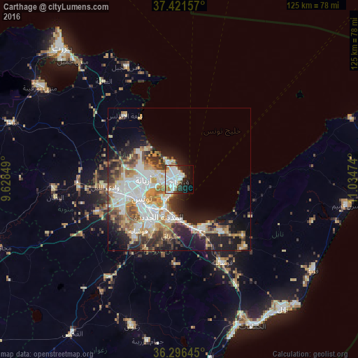
Analysis of Carthage night lights 2016
Square area 10x10 km:
 20.29%
90-99
17.69%80-89
2.44%70-79
2.6%60-69
5.52%50-59
3.08%40-49
3.9%30-39
1.95%20-29
11.2%10-19
14.61%0-9
16.72%Square area 50x50 km:
7.11%90-99
5.65%80-89
2.94%70-79
4.26%60-69
4.17%50-59
2.7%40-49
3.13%30-39
3.69%20-29
5.26%10-19
10.54%0-9
50.55%Clear (daylight) street map image can be seen on geolist.org.
Map coordinates:
37° 25' 17.7" North, 9° 37' 42.6" East
36° 51' 39.9" North, 10° 19' 53.8" East
36° 17' 47.2" North, 11° 2' 5.1" East
Some cities around Carthage sort by population:
• Tunis
15.5 km =9.6 mi,  252°
252°
• Ariana
12.3 km =7.6 mi,  269°
269°
• La Goulette
5.3 km =3.3 mi,  206°
206°
• Ben Arous
15.4 km =9.6 mi,  219°
219°
• Al Marsá
2 km =1.2 mi,  341°
341°
• Hammam-Lif
14.8 km =9.2 mi,  176°
176°
• Radès
11.4 km =7.1 mi, 206°
• La Sebala du Mornag
20.5 km =12.7 mi,  189°
189°
2468245 (p: 15,922)
Sources (retrieved 2019-11-25):
» Earth at Night: Flat Maps 2012, 2016