Wiang Sa night lights from space
Night Light of Wiang Sa (Surat Thani) from space (Thailand) Src. Average luminocity for 10x10km area is 15.6963% and for 50x50km: 1.8013%.
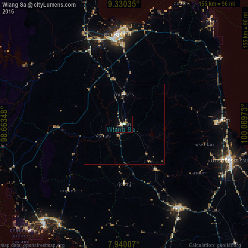
Analysis of Wiang Sa night lights 2016
Square area 10x10 km:
 0.62%
0.62%90-99
1.45%80-89
2.89%70-79
3.93%60-69
3.1%50-59
1.24%40-49
1.65%30-39
0.83%20-29
1.65%10-19
2.27%0-9
80.37%Square area 50x50 km:
0.07%90-99
0.12%80-89
0.24%70-79
0.31%60-69
0.4%50-59
0.27%40-49
0.32%30-39
0.3%20-29
0.37%10-19
0.28%0-9
97.33%Clear (daylight) street map image can be seen on geolist.org.
Map coordinates:
9° 19' 49.3" North, 98° 39' 48.5" East
8° 38' 9.1" North, 99° 21' 59.8" East
7° 56' 24.3" North, 100° 4' 11" East
Some cities around Wiang Sa sort by population:
• Surat Thani
56.2 km =34.9 mi,  356°
356°
• Thung Song
62.8 km =39 mi,  146°
146°
• Tha Kham
54.8 km =34.1 mi,  344°
344°
• Ban Na San
18.3 km =11.4 mi, 359°
• Chawang
27.8 km =17.3 mi, 146°
• Tha Khanon
63.2 km =39.3 mi,  313°
313°
• Tham Phannara
24.2 km =15 mi,  172°
172°
• Chai Buri
37.3 km =23.2 mi,  238°
238°
1149878 (p: 11,933)
Sources (retrieved 2019-11-25):
» Earth at Night: Flat Maps 2012, 2016