Chai Buri night lights from space
Night Light of Chai Buri (Surat Thani) from space (Thailand) Src. Average luminocity for 10x10km area is 2.1426% and for 50x50km: 0.7806%.
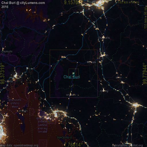
Analysis of Chai Buri night lights 2016
Square area 10x10 km:
 0%
0%90-99
0%80-89
0%70-79
0.83%60-69
0.83%50-59
0%40-49
1.65%30-39
0%20-29
0.41%10-19
0%0-9
96.28%Square area 50x50 km:
0%90-99
0.03%80-89
0.01%70-79
0.2%60-69
0.19%50-59
0.25%40-49
0.19%30-39
0.05%20-29
0.34%10-19
0.13%0-9
98.6%Clear (daylight) street map image can be seen on geolist.org.
Map coordinates:
9° 9' 25.4" North, 98° 22' 23.5" East
8° 27' 44" North, 99° 4' 34.7" East
7° 45' 58.1" North, 99° 46' 46" East
Some cities around Chai Buri sort by population:
• Krabi
47 km =29.2 mi,  202°
202°
• Ban Na San
49.1 km =30.5 mi,  40°
40°
• Nuea Khlong
44.3 km =27.5 mi,  191°
191°
• Wiang Sa
37.3 km =23.2 mi,  58°
58°
• Chawang
47.3 km =29.4 mi,  94°
94°
• Ao Luek
40.2 km =25 mi,  256°
256°
• Ban Ao Nang
54.8 km =34.1 mi,  212°
212°
• Tham Phannara
35.4 km =22 mi,  97°
97°
1153788 (p: 6,126)
Sources (retrieved 2019-11-25):
» Earth at Night: Flat Maps 2012, 2016