Ban Selaphum night lights from space
Night Light of Ban Selaphum (Roi Et) from space (Thailand) Src. Average luminocity for 10x10km area is 9.9917% and for 50x50km: 3.7736%.
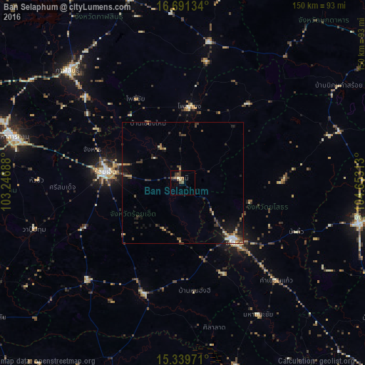
Analysis of Ban Selaphum night lights 2016
Square area 10x10 km:
 0%
0%90-99
0.83%80-89
1.65%70-79
0%60-69
1.45%50-59
3.31%40-49
5.58%30-39
2.07%20-29
0.83%10-19
0%0-9
84.3%Square area 50x50 km:
0.18%90-99
0.43%80-89
0.37%70-79
0.48%60-69
0.45%50-59
0.54%40-49
1.03%30-39
0.95%20-29
0.99%10-19
2.41%0-9
92.16%Clear (daylight) street map image can be seen on geolist.org.
Map coordinates:
16° 41' 28.8" North, 103° 14' 48.8" East
16° 1' 0" North, 103° 57' 0" East
15° 20' 23" North, 104° 39' 11.3" East
Some cities around Ban Selaphum sort by population:
• Roi Et
32 km =19.9 mi,  277°
277°
• Kamalasai
53.6 km =33.3 mi,  311°
311°
• Yasothon
32.4 km =20.1 mi,  139°
139°
• Kaset Wisai
56.1 km =34.9 mi,  224°
224°
• Pho Chai
39.6 km =24.6 mi,  331°
331°
• Waeng
31.7 km =19.7 mi,  5°
5°
• Suwannaphum
48.6 km =30.2 mi,  199°
199°
• Moeiwadi
47 km =29.2 mi,  28°
28°
1613284 (p: 17,412)
Sources (retrieved 2019-11-25):
» Earth at Night: Flat Maps 2012, 2016