Sai Buri night lights from space
Night Light of Sai Buri (Pattani) from space (Thailand) Src. Average luminocity for 10x10km area is 12.7251% and for 50x50km: 4.0665%.
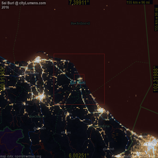
Analysis of Sai Buri night lights 2016
Square area 10x10 km:
 0%
0%90-99
0.87%80-89
3.03%70-79
3.03%60-69
3.46%50-59
0%40-49
0.43%30-39
3.46%20-29
2.6%10-19
1.73%0-9
81.39%Square area 50x50 km:
0.02%90-99
0.05%80-89
0.51%70-79
0.75%60-69
0.64%50-59
0.8%40-49
0.92%30-39
1.05%20-29
0.93%10-19
0.54%0-9
93.8%Clear (daylight) street map image can be seen on geolist.org.
Map coordinates:
7° 23' 56.8" North, 100° 54' 49.1" East
6° 42' 4.7" North, 101° 37' 0.3" East
6° 0' 9" North, 102° 19' 11.6" East
Some cities around Sai Buri sort by population:
• Yala
41.2 km =25.6 mi,  244°
244°
• Narathiwat
38.1 km =23.7 mi,  143°
143°
• Pattani
44.5 km =27.7 mi,  294°
294°
• Yaring
32.9 km =20.4 mi,  303°
303°
• Tak Bai
68.9 km =42.8 mi, 135°
• Ra-ngae
46.6 km =29 mi,  164°
164°
• Ban Su-ngai Pa Di
75.4 km =46.9 mi, 158°
• Nong Chik
51 km =31.7 mi, 288°
1606851 (p: 14,356)
Sources (retrieved 2019-11-25):
» Earth at Night: Flat Maps 2012, 2016