Pattani night lights from space
Night Light of Pattani from space (Thailand) Src. Average luminocity for 10x10km area is 56.3528% and for 50x50km: 10.307%.
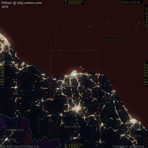

Analysis of Pattani night lights 2016
Square area 10x10 km:
 12.12%
90-99
12.55%80-89
4.55%70-79
10.82%60-69
6.28%50-59
4.76%40-49
7.36%30-39
10.17%20-29
18.4%10-19
12.77%0-9
0.22%Square area 50x50 km:
0.63%90-99
0.81%80-89
1.32%70-79
1.65%60-69
1.49%50-59
1.27%40-49
1.57%30-39
1.8%20-29
3.52%10-19
8.96%0-9
76.97%Clear (daylight) street map image can be seen on geolist.org.
Map coordinates:
7° 33' 56.5" North, 100° 32' 49.1" East
6° 52' 5.3" North, 101° 15' 0.3" East
6° 10' 10.5" North, 101° 57' 11.6" East
Some cities around Pattani sort by population:
• Yala
36.7 km =22.8 mi,  174°
174°
• Songkhla
81.1 km =50.4 mi,  296°
296°
• Narathiwat
80.1 km =49.8 mi,  127°
127°
• Yaring
13.1 km =8.1 mi,  90°
90°
• Ra-ngae
82.6 km =51.3 mi,  140°
140°
• Sai Buri
44.5 km =27.7 mi,  114°
114°
• Nong Chik
8.4 km =5.2 mi,  251°
251°
• Na Mom
77.2 km =48 mi,  277°
277°
1607978 (p: 43,690)
Sources (retrieved 2019-11-25):
» Earth at Night: Flat Maps 2012, 2016