Ra-ngae night lights from space
Night Light of Ra-ngae (Narathiwat) from space (Thailand) Src. Average luminocity for 10x10km area is 16.0952% and for 50x50km: 6.9587%.
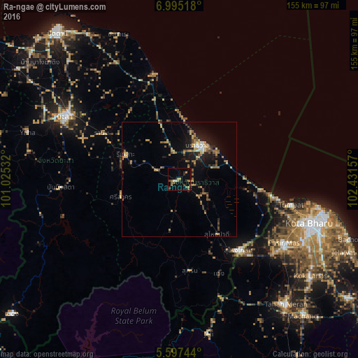
Analysis of Ra-ngae night lights 2016
Square area 10x10 km:
 0.43%
0.43%90-99
1.3%80-89
0%70-79
4.11%60-69
3.03%50-59
3.68%40-49
2.6%30-39
2.81%20-29
3.9%10-19
2.16%0-9
75.97%Square area 50x50 km:
0.32%90-99
0.39%80-89
0.9%70-79
1.44%60-69
1.25%50-59
1.19%40-49
0.87%30-39
0.93%20-29
1.62%10-19
4.52%0-9
86.57%Clear (daylight) street map image can be seen on geolist.org.
Map coordinates:
6° 59' 42.6" North, 101° 1' 31.2" East
6° 17' 48.4" North, 101° 43' 42.4" East
5° 35' 50.8" North, 102° 25' 53.7" East
Some cities around Ra-ngae sort by population:
• Yala
56.3 km =35 mi,  298°
298°
• Narathiwat
17.8 km =11.1 mi,  35°
35°
• Su-ngai Kolok
39.6 km =24.6 mi,  138°
138°
• Pasir Mas, MY
53.2 km =33.1 mi,  121°
121°
• Tak Bai
36.3 km =22.6 mi,  96°
96°
• Sai Buri
46.6 km =29 mi,  344°
344°
• Ban Su-ngai Pa Di
29.6 km =18.4 mi,  147°
147°
• Tumpat, MY
50.1 km =31.1 mi, 102°
1607083 (p: 16,862)
Sources (retrieved 2019-11-25):
» Earth at Night: Flat Maps 2012, 2016