Phon night lights from space
Night Light of Phon (Khon Kaen) from space (Thailand) Src. Average luminocity for 10x10km area is 16.1234% and for 50x50km: 2.3998%.
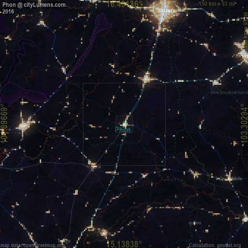
Analysis of Phon night lights 2016
Square area 10x10 km:
 0.87%
0.87%90-99
2.38%80-89
3.68%70-79
1.73%60-69
0.87%50-59
2.6%40-49
2.6%30-39
2.6%20-29
2.6%10-19
1.73%0-9
78.35%Square area 50x50 km:
0.05%90-99
0.23%80-89
0.3%70-79
0.35%60-69
0.41%50-59
0.32%40-49
0.42%30-39
0.57%20-29
0.51%10-19
0.79%0-9
96.05%Clear (daylight) street map image can be seen on geolist.org.
Map coordinates:
16° 29' 28.9" North, 101° 53' 48.1" East
15° 48' 57.6" North, 102° 35' 59.3" East
15° 8' 18.2" North, 103° 18' 10.6" East
Some cities around Phon sort by population:
• Chaiyaphum
61.1 km =38 mi,  269°
269°
• Ban Phai
30.5 km =19 mi,  27°
27°
• Kaeng Khro
48.9 km =30.4 mi,  311°
311°
• Bua Yai
31.7 km =19.7 mi,  215°
215°
• Phimai
66.9 km =41.6 mi,  189°
189°
• Kham Sakae Saeng
70.6 km =43.9 mi, 220°
• Kosum Phisai
69.4 km =43.1 mi,  46°
46°
• Phayakkhaphum Phisai
71.8 km =44.6 mi,  117°
117°
1607617 (p: 14,596)
Sources (retrieved 2019-11-25):
» Earth at Night: Flat Maps 2012, 2016