Lan Krabue night lights from space
Night Light of Lan Krabue (Kamphaeng Phet) from space (Thailand) Src. Average luminocity for 10x10km area is 35.1926% and for 50x50km: 3.1993%.
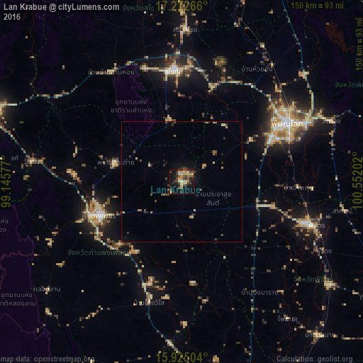
Analysis of Lan Krabue night lights 2016
Square area 10x10 km:
 0.43%
0.43%90-99
3.25%80-89
10.39%70-79
5.84%60-69
4.11%50-59
4.98%40-49
8.66%30-39
8.44%20-29
6.28%10-19
25.97%0-9
21.65%Square area 50x50 km:
0.02%90-99
0.17%80-89
0.72%70-79
0.43%60-69
0.42%50-59
0.38%40-49
0.86%30-39
0.71%20-29
0.63%10-19
1.89%0-9
93.78%Clear (daylight) street map image can be seen on geolist.org.
Map coordinates:
17° 16' 21.6" North, 99° 8' 44.8" East
16° 36' 0.1" North, 99° 50' 56" East
15° 55' 30.1" North, 100° 33' 7.3" East
Some cities around Lan Krabue sort by population:
• Phitsanulok
50.3 km =31.3 mi,  60°
60°
• Kamphaeng Phet
37.2 km =23.1 mi,  249°
249°
• Ban Na
48 km =29.8 mi,  345°
345°
• Sukhothai
45.4 km =28.2 mi,  356°
356°
• Bang Krathum
48.2 km =30 mi,  92°
92°
• Bang Rakam
33.6 km =20.9 mi, 58°
• Khiri Mat
26.5 km =16.5 mi, 348°
• Ban Dan Lan Hoi
53.8 km =33.4 mi,  327°
327°
1152423 (p: 7,633)
Sources (retrieved 2019-11-25):
» Earth at Night: Flat Maps 2012, 2016