Khiri Mat night lights from space
Night Light of Khiri Mat (Sukhothai) from space (Thailand) Src. Average luminocity for 10x10km area is 8.6364% and for 50x50km: 8.2886%.
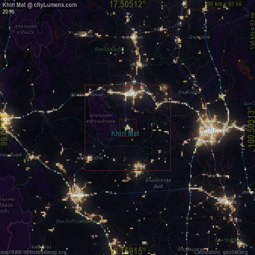
Analysis of Khiri Mat night lights 2016
Square area 10x10 km:
 0%
0%90-99
0.43%80-89
2.16%70-79
1.73%60-69
0.87%50-59
1.3%40-49
2.16%30-39
2.16%20-29
2.16%10-19
0.87%0-9
86.15%Square area 50x50 km:
0.29%90-99
0.65%80-89
1.76%70-79
1.17%60-69
0.8%50-59
0.89%40-49
1.99%30-39
2.04%20-29
2.61%10-19
5.73%0-9
82.06%Clear (daylight) street map image can be seen on geolist.org.
Map coordinates:
17° 30' 18.4" North, 99° 5' 48.8" East
16° 49' 60" North, 99° 48' 0" East
16° 9' 32.9" North, 100° 30' 11.3" East
Some cities around Khiri Mat sort by population:
• Phitsanulok
48.8 km =30.3 mi,  91°
91°
• Kamphaeng Phet
48.9 km =30.4 mi,  217°
217°
• Ban Na
21.7 km =13.5 mi,  340°
340°
• Sukhothai
19.6 km =12.2 mi,  7°
7°
• Sawankhalok
53.8 km =33.4 mi,  3°
3°
• Bang Rakam
34.8 km =21.6 mi,  103°
103°
• Lan Krabue
26.5 km =16.5 mi,  168°
168°
• Ban Dan Lan Hoi
30.7 km =19.1 mi,  308°
308°
1152876 (p: 11,272)
Sources (retrieved 2019-11-25):
» Earth at Night: Flat Maps 2012, 2016