Bang Krathum night lights from space
Night Light of Bang Krathum (Phitsanulok) from space (Thailand) Src. Average luminocity for 10x10km area is 4.8506% and for 50x50km: 9.7674%.
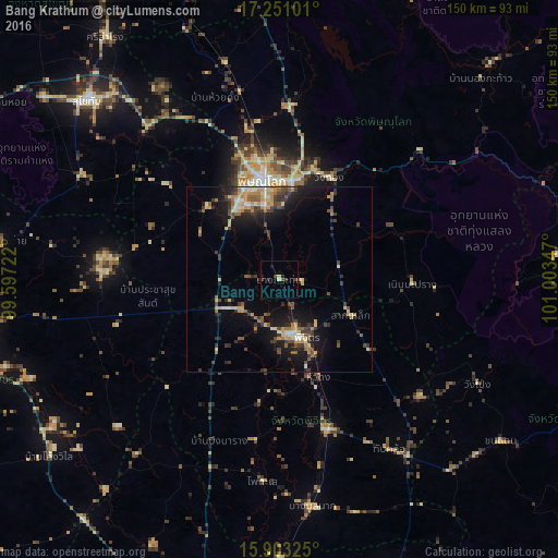
Analysis of Bang Krathum night lights 2016
Square area 10x10 km:
 0%
0%90-99
0%80-89
1.73%70-79
0%60-69
0%50-59
0%40-49
1.52%30-39
2.81%20-29
1.52%10-19
2.16%0-9
90.26%Square area 50x50 km:
0.36%90-99
0.9%80-89
1.74%70-79
1.69%60-69
1.13%50-59
1.47%40-49
1.65%30-39
2.53%20-29
2.18%10-19
7.26%0-9
79.09%Clear (daylight) street map image can be seen on geolist.org.
Map coordinates:
17° 15' 3.6" North, 99° 35' 50" East
16° 34' 41.9" North, 100° 18' 1.2" East
15° 54' 11.7" North, 101° 0' 12.5" East
Some cities around Bang Krathum sort by population:
• Phitsanulok
27.8 km =17.3 mi,  350°
350°
• Sukhothai
69.7 km =43.3 mi,  313°
313°
• Phichit
16 km =9.9 mi,  161°
161°
• Taphan Hin
41.7 km =25.9 mi, 162°
• Thap Khlo
56.2 km =34.9 mi,  145°
145°
• Khiri Mat
60.4 km =37.5 mi,  298°
298°
• Wang Sai Phun
33 km =20.5 mi,  129°
129°
• Lan Krabue
48.2 km =30 mi,  272°
272°
1619437 (p: 18,874)
Sources (retrieved 2019-11-25):
» Earth at Night: Flat Maps 2012, 2016