Bang Rakam night lights from space
Night Light of Bang Rakam (Phitsanulok) from space (Thailand) Src. Average luminocity for 10x10km area is 9.3918% and for 50x50km: 12.9146%.
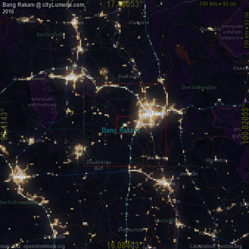
Analysis of Bang Rakam night lights 2016
Square area 10x10 km:
 0%
0%90-99
0.43%80-89
1.73%70-79
0.43%60-69
0.87%50-59
1.73%40-49
0%30-39
2.16%20-29
1.52%10-19
18.4%0-9
72.73%Square area 50x50 km:
0.92%90-99
1.61%80-89
2.4%70-79
2.74%60-69
1.19%50-59
1.79%40-49
2.25%30-39
2.44%20-29
2.95%10-19
6.85%0-9
74.87%Clear (daylight) street map image can be seen on geolist.org.
Map coordinates:
17° 25' 49.9" North, 99° 24' 51.5" East
16° 45' 30.5" North, 100° 7' 2.7" East
16° 5' 2.5" North, 100° 49' 14" East
Some cities around Bang Rakam sort by population:
• Phitsanulok
16.7 km =10.4 mi,  63°
63°
• Ban Na
50 km =31.1 mi,  305°
305°
• Sukhothai
41.8 km =26 mi, 311°
• Phichit
43 km =26.7 mi,  144°
144°
• Khiri Mat
34.8 km =21.6 mi,  283°
283°
• Wang Sai Phun
60.8 km =37.8 mi,  132°
132°
• Lan Krabue
33.6 km =20.9 mi,  238°
238°
• Ban Dan Lan Hoi
64 km =39.8 mi,  295°
295°
1619276 (p: 16,841)
Sources (retrieved 2019-11-25):
» Earth at Night: Flat Maps 2012, 2016