Chom Bueng night lights from space
Night Light of Chom Bueng (Ratchaburi) from space (Thailand) Src. Average luminocity for 10x10km area is 9.2355% and for 50x50km: 8.5112%.
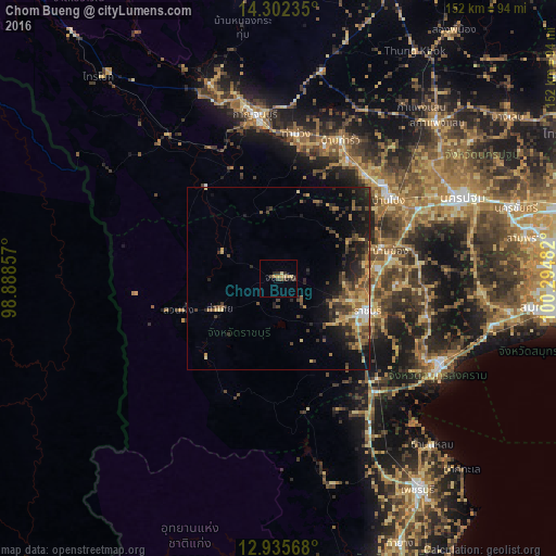
Analysis of Chom Bueng night lights 2016
Square area 10x10 km:
 0%
0%90-99
0%80-89
2.48%70-79
2.89%60-69
0.41%50-59
0%40-49
3.31%30-39
1.65%20-29
2.48%10-19
1.65%0-9
85.12%Square area 50x50 km:
0.28%90-99
0.46%80-89
1.22%70-79
1.39%60-69
1.57%50-59
1.46%40-49
1.97%30-39
2.38%20-29
2.74%10-19
5.64%0-9
80.89%Clear (daylight) street map image can be seen on geolist.org.
Map coordinates:
14° 18' 8.5" North, 98° 53' 18.9" East
13° 37' 12" North, 99° 35' 30.1" East
12° 56' 8.4" North, 100° 17' 41.4" East
Some cities around Chom Bueng sort by population:
• Ratchaburi
26.1 km =16.2 mi,  110°
110°
• Kanchanaburi
43 km =26.7 mi,  353°
353°
• Ban Pong
37.8 km =23.5 mi,  54°
54°
• Tha Maka
36.4 km =22.6 mi,  31°
31°
• Photharam
29 km =18 mi,  73°
73°
• Bang Phae
37.4 km =23.2 mi,  77°
77°
• Tha Muang
38.3 km =23.8 mi,  8°
8°
• Damnoen Saduak
40.8 km =25.4 mi, 106°
1153646 (p: 15,143)
Sources (retrieved 2019-11-25):
» Earth at Night: Flat Maps 2012, 2016