Mhlume night lights from space
Night Light of Mhlume (Lubombo) from space (Eswatini) Src. Average luminocity for 10x10km area is 3.6885% and for 50x50km: 1.247%.
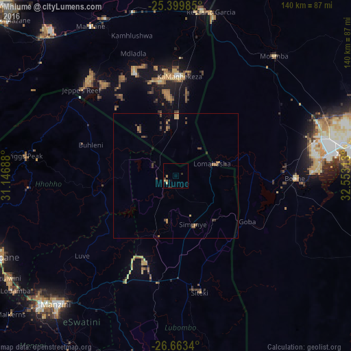
Analysis of Mhlume night lights 2016
Square area 10x10 km:
 0%
0%90-99
0%80-89
1.59%70-79
0%60-69
1.59%50-59
0%40-49
0.2%30-39
1.19%20-29
1.39%10-19
0.79%0-9
93.25%Square area 50x50 km:
0%90-99
0%80-89
0.11%70-79
0.21%60-69
0.4%50-59
0.2%40-49
0.44%30-39
0.28%20-29
0.45%10-19
0.16%0-9
97.75%Clear (daylight) street map image can be seen on geolist.org.
Map coordinates:
25° 23' 59.5" South, 31° 8' 48.8" East
26° 1' 60" South, 31° 51' 0" East
26° 39' 48.2" South, 32° 33' 11.3" East
Some cities around Mhlume sort by population:
• Maputo, MZ
73.7 km =45.8 mi,  84°
84°
• Matola, MZ
61.4 km =38.2 mi, 82°
• Manzini
69.8 km =43.4 mi,  222°
222°
• Ressano Garcia, MZ
67.3 km =41.8 mi,  12°
12°
• Mbabane
78.1 km =48.5 mi,  246°
246°
• Komatipoort, ZA
67.5 km =41.9 mi, 8°
• Siteki
47.6 km =29.6 mi,  168°
168°
• Piggs Peak
60.8 km =37.8 mi,  277°
277°
934966 (p: 8,652)
Sources (retrieved 2019-11-25):
» Earth at Night: Flat Maps 2012, 2016