Piggs Peak night lights from space
Night Light of Piggs Peak (Hhohho) from space (Eswatini) Src. Average luminocity for 10x10km area is 4.7044% and for 50x50km: 1.3906%.
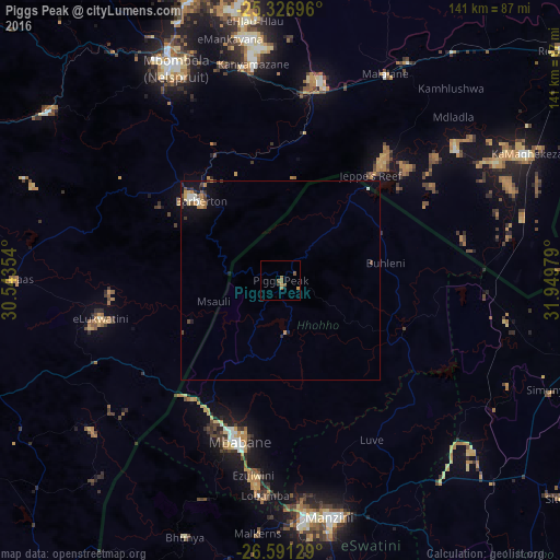
Analysis of Piggs Peak night lights 2016
Square area 10x10 km:
 0%
0%90-99
0%80-89
0%70-79
1.59%60-69
1.98%50-59
2.18%40-49
0.6%30-39
0%20-29
0.79%10-19
0.6%0-9
92.26%Square area 50x50 km:
0.15%90-99
0.13%80-89
0.1%70-79
0.28%60-69
0.24%50-59
0.16%40-49
0.29%30-39
0.21%20-29
0.23%10-19
1.03%0-9
97.18%Clear (daylight) street map image can be seen on geolist.org.
Map coordinates:
25° 19' 37.1" South, 30° 32' 36.7" East
25° 57' 39" South, 31° 14' 48" East
26° 35' 28.6" South, 31° 56' 59.2" East
Some cities around Piggs Peak sort by population:
• Manzini
61.3 km =38.1 mi,  167°
167°
• Nelspruit, ZA
60.7 km =37.7 mi,  332°
332°
• Mbabane
41.2 km =25.6 mi,  195°
195°
• Barberton, ZA
27.2 km =16.9 mi,  314°
314°
• White River, ZA
73.8 km =45.9 mi,  341°
341°
• Malkerns
67.7 km =42.1 mi,  185°
185°
• Mhlume
60.8 km =37.8 mi,  97°
97°
• Lobamba
56.4 km =35 mi,  184°
184°
934881 (p: 5,750)
Sources (retrieved 2019-11-25):
» Earth at Night: Flat Maps 2012, 2016