Komatipoort night lights from space
Night Light of Komatipoort (Mpumalanga) from space (South Africa) Src. Average luminocity for 10x10km area is 18.4782% and for 50x50km: 1.8388%.

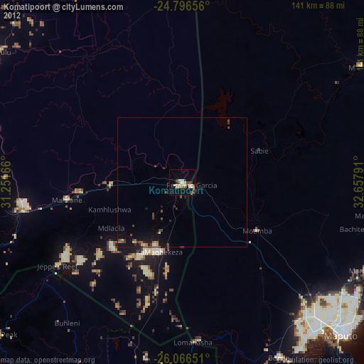
Analysis of Komatipoort night lights 2016
Square area 10x10 km:
 0%
0%90-99
0.79%80-89
5.95%70-79
3.17%60-69
3.57%50-59
4.56%40-49
1.39%30-39
1.98%20-29
1.39%10-19
7.54%0-9
69.64%Square area 50x50 km:
0%90-99
0.03%80-89
0.34%70-79
0.26%60-69
0.44%50-59
0.36%40-49
0.16%30-39
0.24%20-29
0.26%10-19
1.7%0-9
96.2%Clear (daylight) street map image can be seen on geolist.org.
Map coordinates:
24° 47' 47.6" South, 31° 15' 6" East
25° 25' 59.6" South, 31° 57' 17.2" East
26° 3' 59.4" South, 32° 39' 28.5" East
Some cities around Komatipoort sort by population:
• Maputo, MZ
86.4 km =53.7 mi,  133°
133°
• Matola, MZ
77.5 km =48.2 mi,  139°
139°
• Nelspruit
98.9 km =61.5 mi,  267°
267°
• Ressano Garcia, MZ
4.2 km =2.6 mi,  104°
104°
• Barberton
98.6 km =61.3 mi,  246°
246°
• White River
95.4 km =59.3 mi,  276°
276°
• Mhlume, SZ
67.5 km =41.9 mi,  188°
188°
• Piggs Peak, SZ
92.1 km =57.2 mi,  230°
230°
988290 (p: 20,508)
Sources (retrieved 2019-11-25):
» Earth at Night: Flat Maps 2012, 2016