Nieuw Amsterdam night lights from space
Night Light of Nieuw Amsterdam (Commewijne) from space (Suriname) Src. Average luminocity for 10x10km area is 30.2769% and for 50x50km: 15.5032%.
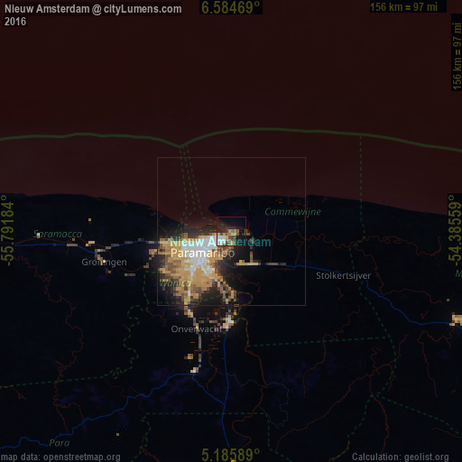
Analysis of Nieuw Amsterdam night lights 2016
Square area 10x10 km:
 4.13%
4.13%90-99
6.4%80-89
3.51%70-79
3.72%60-69
2.48%50-59
1.86%40-49
9.92%30-39
3.1%20-29
5.99%10-19
22.31%0-9
36.57%Square area 50x50 km:
2.16%90-99
1.95%80-89
2.07%70-79
4.65%60-69
1.76%50-59
1.65%40-49
3.01%30-39
1.72%20-29
3.88%10-19
6.66%0-9
70.48%Clear (daylight) street map image can be seen on geolist.org.
Map coordinates:
6° 35' 4.9" North, 55° 47' 30.6" West
5° 53' 8.6" North, 55° 5' 19.4" West
5° 11' 9.2" North, 54° 23' 8.1" West
Some cities around Nieuw Amsterdam sort by population:
• Paramaribo
8.9 km =5.5 mi,  256°
256°
• Saint-Laurent-du-Maroni, GF
124.8 km =77.5 mi,  110°
110°
• Lelydorp
26.1 km =16.2 mi,  217°
217°
• Brokopondo
93 km =57.8 mi,  172°
172°
• Moengo
81.8 km =50.8 mi, 111°
• Albina
122.2 km =75.9 mi, 110°
• Groningen
42.9 km =26.7 mi, 257°
• Onverwacht
34.9 km =21.7 mi,  199°
199°
3383434 (p: 4,935)
Sources (retrieved 2019-11-25):
» Earth at Night: Flat Maps 2012, 2016