Sevnica night lights from space
Night Light of Sevnica from space (Slovenia) Src. Average luminocity for 10x10km area is 1.9474% and for 50x50km: 2.8804%.
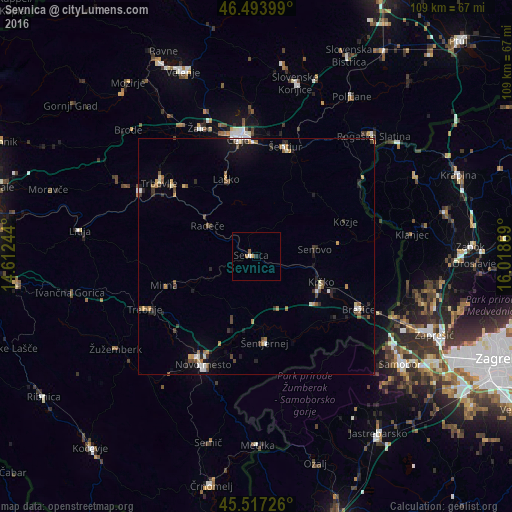
Analysis of Sevnica night lights 2016
Square area 10x10 km:
 0.28%
0.28%90-99
0.28%80-89
0%70-79
0.43%60-69
0.71%50-59
0.57%40-49
0%30-39
0%20-29
0.57%10-19
0%0-9
97.16%Square area 50x50 km:
0.25%90-99
0.37%80-89
0.18%70-79
0.39%60-69
0.41%50-59
0.47%40-49
0.46%30-39
0.44%20-29
0.77%10-19
1.2%0-9
95.06%Clear (daylight) street map image can be seen on geolist.org.
Map coordinates:
46° 29' 38.4" North, 14° 36' 44.8" East
46° 0' 28" North, 15° 18' 56" East
45° 31' 2.1" North, 16° 1' 7.3" East
Some cities around Sevnica sort by population:
• Krško
14.6 km =9.1 mi,  111°
111°
• Laško
17.5 km =10.9 mi,  339°
339°
• Radeče
12.2 km =7.6 mi,  303°
303°
• Mokronog
15.8 km =9.8 mi,  238°
238°
• Šentrupert
17.3 km =10.7 mi,  258°
258°
• Šmarjeta
14.7 km =9.1 mi,  200°
200°
• Škocjan
11.4 km =7.1 mi,  189°
189°
• Dobje pri Planini
15.6 km =9.7 mi,  22°
22°
3190950 (p: 4,660)
Sources (retrieved 2019-11-25):
» Earth at Night: Flat Maps 2012, 2016