Šentrupert night lights from space
Night Light of Šentrupert from space (Slovenia) Src. Average luminocity for 10x10km area is 1.1696% and for 50x50km: 2.0012%.
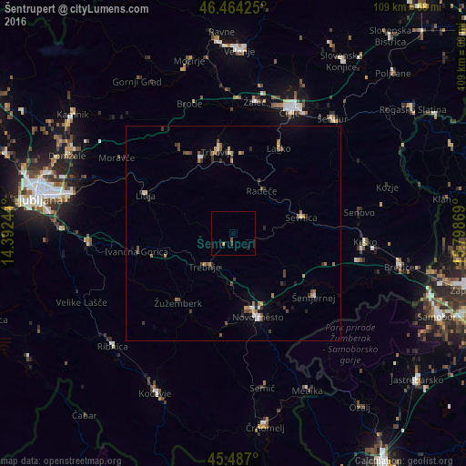
Analysis of Šentrupert night lights 2016
Square area 10x10 km:
100  0%
0%
90-99 0%
80-89 0%
70-79 0.6%
60-69 0%
50-59 0.6%
40-49 0%
30-39 0.6%
20-29 0%
10-19 0.6%
0-9 97.62%
0%90-99
0%80-89
0%70-79
0.6%60-69
0%50-59
0.6%40-49
0%30-39
0.6%20-29
0%10-19
0.6%0-9
97.62%Square area 50x50 km:
100 0.16%
90-99 0.18%
80-89 0.12%
70-79 0.26%
60-69 0.39%
50-59 0.36%
40-49 0.45%
30-39 0.36%
20-29 0.4%
10-19 0.46%
0-9 96.85%
0.16%90-99
0.18%80-89
0.12%70-79
0.26%60-69
0.39%50-59
0.36%40-49
0.45%30-39
0.36%20-29
0.4%10-19
0.46%0-9
96.85%Clear (daylight) street map image can be seen on geolist.org.
Map coordinates:
46° 27' 51.3" North, 14° 23' 32.8" East
45° 58' 40" North, 15° 5' 44" East
45° 29' 13.2" North, 15° 47' 55.3" East
Some cities around Šentrupert sort by population:
• Sevnica
17.3 km =10.7 mi,  78°
78°
• Trebnje
10 km =6.2 mi,  214°
214°
• Radeče
12.1 km =7.5 mi,  34°
34°
• Mirna
3.6 km =2.2 mi,  226°
226°
• Mirna Peč
13.1 km =8.1 mi,  184°
184°
• Mokronog
6 km =3.7 mi,  144°
144°
• Šmarjeta
15.9 km =9.9 mi,  131°
131°
• Škocjan
17.1 km =10.6 mi,  117°
117°
3191024 (p: 329)
Sources (retrieved 2019-11-25):
» Earth at Night: Flat Maps 2012, 2016