Laško night lights from space
Night Light of Laško from space (Slovenia) Src. Average luminocity for 10x10km area is 2.3438% and for 50x50km: 3.8435%.
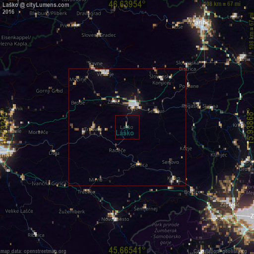
Analysis of Laško night lights 2016
Square area 10x10 km:
100  0%
0%
90-99 0%
80-89 0%
70-79 0.57%
60-69 0.28%
50-59 1.14%
40-49 0.28%
30-39 0%
20-29 0%
10-19 0.14%
0-9 97.59%
0%90-99
0%80-89
0%70-79
0.57%60-69
0.28%50-59
1.14%40-49
0.28%30-39
0%20-29
0%10-19
0.14%0-9
97.59%Square area 50x50 km:
100 0.42%
90-99 0.68%
80-89 0.3%
70-79 0.37%
60-69 0.42%
50-59 0.68%
40-49 0.53%
30-39 0.56%
20-29 0.67%
10-19 1.93%
0-9 93.44%
0.42%90-99
0.68%80-89
0.3%70-79
0.37%60-69
0.42%50-59
0.68%40-49
0.53%30-39
0.56%20-29
0.67%10-19
1.93%0-9
93.44%Clear (daylight) street map image can be seen on geolist.org.
Map coordinates:
46° 38' 22.3" North, 14° 31' 56.7" East
46° 9' 16.7" North, 15° 14' 8" East
45° 39' 55.5" North, 15° 56' 19.2" East
Some cities around Laško sort by population:
• Celje
8.7 km =5.4 mi,  12°
12°
• Trbovlje
14 km =8.7 mi,  270°
270°
• Hrastnik
11.9 km =7.4 mi, 265°
• Žalec
12.1 km =7.5 mi,  333°
333°
• Šentjur
14.3 km =8.9 mi,  60°
60°
• Radeče
10.4 km =6.5 mi,  202°
202°
• Štore
9.5 km =5.9 mi,  39°
39°
• Dobje pri Planini
12.4 km =7.7 mi,  98°
98°
3196760 (p: 3,456)
Sources (retrieved 2019-11-25):
» Earth at Night: Flat Maps 2012, 2016