Lucija night lights from space
Night Light of Lucija (Piran-Pirano) from space (Slovenia) Src. Average luminocity for 10x10km area is 19.2127% and for 50x50km: 9.3779%.
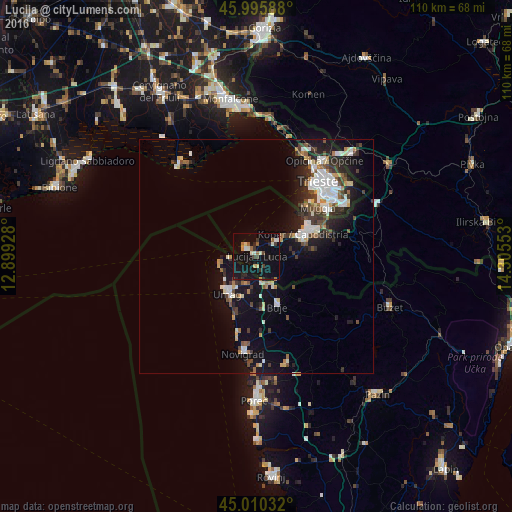
Analysis of Lucija night lights 2016
Square area 10x10 km:
 0.79%
0.79%90-99
3.97%80-89
1.9%70-79
0.63%60-69
2.54%50-59
1.9%40-49
2.38%30-39
3.02%20-29
4.13%10-19
32.7%0-9
46.03%Square area 50x50 km:
1.44%90-99
2.15%80-89
0.63%70-79
0.75%60-69
0.79%50-59
0.88%40-49
1.39%30-39
1.58%20-29
2.31%10-19
7.99%0-9
80.1%Clear (daylight) street map image can be seen on geolist.org.
Map coordinates:
45° 59' 45.2" North, 12° 53' 57.4" East
45° 30' 18.9" North, 13° 36' 8.6" East
45° 0' 37.2" North, 14° 18' 19.9" East
Some cities around Lucija sort by population:
• Trieste, IT
21 km =13 mi,  40°
40°
• Koper
10.9 km =6.8 mi,  64°
64°
• Izola
5.8 km =3.6 mi,  52°
52°
• Muggia, IT
16.9 km =10.5 mi, 49°
• Umag, HR
10.2 km =6.3 mi,  216°
216°
• Grado, IT
24.7 km =15.3 mi,  321°
321°
• Piran
3.5 km =2.2 mi, 315°
• Ankaran
13.2 km =8.2 mi, 51°
3343512 (p: 5,872)
Sources (retrieved 2019-11-25):
» Earth at Night: Flat Maps 2012, 2016