Grado night lights from space
Night Light of Grado (Friuli Venezia Giulia) from space (Italy) Src. Average luminocity for 10x10km area is 6.7591% and for 50x50km: 10.1179%.
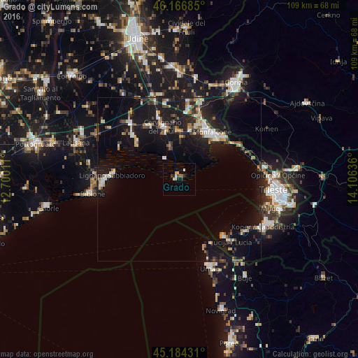
Analysis of Grado night lights 2016
Square area 10x10 km:
 0.45%
0.45%90-99
1.36%80-89
1.67%70-79
0.15%60-69
0.76%50-59
0.45%40-49
0.76%30-39
1.67%20-29
0.45%10-19
1.36%0-9
90.91%Square area 50x50 km:
1.05%90-99
1.6%80-89
1.02%70-79
0.9%60-69
1.03%50-59
1.18%40-49
1.2%30-39
1.32%20-29
2.68%10-19
13.44%0-9
74.59%Clear (daylight) street map image can be seen on geolist.org.
Map coordinates:
46° 10' 0.7" North, 12° 42' 0.4" East
45° 40' 39.9" North, 13° 24' 11.6" East
45° 11' 3.5" North, 14° 6' 22.9" East
Some cities around Grado sort by population:
• Monfalcone
17.3 km =10.7 mi,  35°
35°
• Cervignano del Friuli
16.7 km =10.4 mi,  342°
342°
• Ronchi dei Legionari
18.4 km =11.4 mi,  25°
25°
• Staranzano
15.8 km =9.8 mi, 29°
• San Giorgio di Nogaro
22.4 km =13.9 mi,  318°
318°
• Lucija, SI
24.7 km =15.3 mi,  141°
141°
• Lignano Sabbiadoro
22.2 km =13.8 mi,  269°
269°
• Piran, SI
21.2 km =13.2 mi, 142°
3175960 (p: 6,767)
Sources (retrieved 2019-11-25):
» Earth at Night: Flat Maps 2012, 2016