Muggia night lights from space
Night Light of Muggia (Friuli Venezia Giulia) from space (Italy) Src. Average luminocity for 10x10km area is 55.1894% and for 50x50km: 10.7554%.
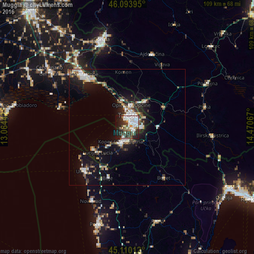
Analysis of Muggia night lights 2016
Square area 10x10 km:
 15.76%
90-99
18.48%80-89
1.21%70-79
3.64%60-69
1.82%50-59
4.7%40-49
8.48%30-39
11.97%20-29
15.61%10-19
15.15%0-9
3.18%Square area 50x50 km:
1.79%90-99
2.41%80-89
0.82%70-79
0.83%60-69
0.88%50-59
1.09%40-49
1.55%30-39
1.72%20-29
2.98%10-19
8.86%0-9
77.08%Clear (daylight) street map image can be seen on geolist.org.
Map coordinates:
46° 5' 38.2" North, 13° 3' 51.9" East
45° 36' 15.1" North, 13° 46' 3.1" East
45° 6' 36.4" North, 14° 28' 14.4" East
Some cities around Muggia sort by population:
• Trieste
5.1 km =3.2 mi,  8°
8°
• Koper, SI
7 km =4.3 mi,  204°
204°
• Izola, SI
11.1 km =6.9 mi,  227°
227°
• Villa Opicina
9.4 km =5.8 mi, 9°
• Lucija, SI
16.9 km =10.5 mi, 229°
• Sežana, SI
14.3 km =8.9 mi,  35°
35°
• Ankaran, SI
3.8 km =2.4 mi,  220°
220°
• Kozina, SI
13.1 km =8.1 mi,  87°
87°
3172483 (p: 10,929)
Sources (retrieved 2019-11-25):
» Earth at Night: Flat Maps 2012, 2016