Ankaran night lights from space
Night Light of Ankaran from space (Slovenia) Src. Average luminocity for 10x10km area is 40.7061% and for 50x50km: 10.1953%.
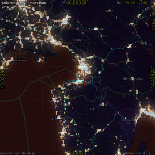
Analysis of Ankaran night lights 2016
Square area 10x10 km:
100  6.21%
6.21%
90-99 12.27%
80-89 1.82%
70-79 4.39%
60-69 1.52%
50-59 4.39%
40-49 9.55%
30-39 12.12%
20-29 9.7%
10-19 21.36%
0-9 16.67%
6.21%90-99
12.27%80-89
1.82%70-79
4.39%60-69
1.52%50-59
4.39%40-49
9.55%30-39
12.12%20-29
9.7%10-19
21.36%0-9
16.67%Square area 50x50 km:
100 1.62%
90-99 2.24%
80-89 0.68%
70-79 0.82%
60-69 0.8%
50-59 1.02%
40-49 1.49%
30-39 1.72%
20-29 2.71%
10-19 8.82%
0-9 78.09%
1.62%90-99
2.24%80-89
0.68%70-79
0.82%60-69
0.8%50-59
1.02%40-49
1.49%30-39
1.72%20-29
2.71%10-19
8.82%0-9
78.09%Clear (daylight) street map image can be seen on geolist.org.
Map coordinates:
46° 4' 6.9" North, 13° 1' 58.8" East
45° 34' 43" North, 13° 44' 10" East
45° 5' 3.5" North, 14° 26' 21.3" East
Some cities around Ankaran sort by population:
• Trieste, IT
8.5 km =5.3 mi,  21°
21°
• Koper
3.6 km =2.2 mi,  188°
188°
• Izola
7.4 km =4.6 mi,  231°
231°
• Muggia, IT
3.8 km =2.4 mi,  40°
40°
• Villa Opicina, IT
12.8 km =8 mi, 18°
• Lucija
13.2 km =8.2 mi, 231°
• Piran
14.1 km =8.8 mi,  246°
246°
• Kozina
15.9 km =9.9 mi,  77°
77°
3220262 (p: 3,278)
Sources (retrieved 2019-11-25):
» Earth at Night: Flat Maps 2012, 2016