Åstorp night lights from space
Night Light of Åstorp (Skåne) from space (Sweden) Src. Average luminocity for 10x10km area is 14.2644% and for 50x50km: 9.0719%.
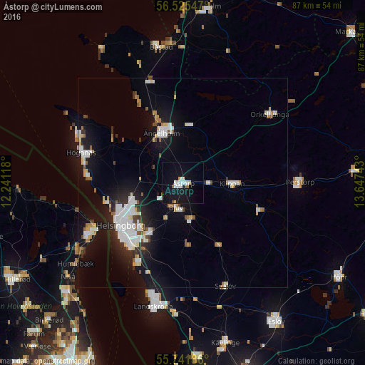
Analysis of Åstorp night lights 2016
Square area 10x10 km:
 2.63%
2.63%90-99
3.59%80-89
1.2%70-79
0.48%60-69
0.96%50-59
0.96%40-49
0.24%30-39
0%20-29
0%10-19
21.17%0-9
68.78%Square area 50x50 km:
2.11%90-99
2.01%80-89
0.69%70-79
0.6%60-69
0.82%50-59
0.74%40-49
0.51%30-39
0.68%20-29
1.78%10-19
7.67%0-9
82.41%Clear (daylight) street map image can be seen on geolist.org.
Map coordinates:
56° 31' 31.7" North, 12° 14' 28.2" East
56° 8' 8.4" North, 12° 56' 39.5" East
55° 44' 30.7" North, 13° 38' 50.7" East
Some cities around Åstorp sort by population:
• Helsingborg
18.4 km =11.4 mi,  237°
237°
• Helsingør, DK
23.3 km =14.5 mi, 241°
• Ängelholm
13 km =8.1 mi,  336°
336°
• Höganäs
25 km =15.5 mi,  286°
286°
• Bjuv
6 km =3.7 mi,  195°
195°
• Klippan
11.6 km =7.2 mi,  90°
90°
• Rydebäck
21.8 km =13.5 mi,  210°
210°
• Ödåkra
12.7 km =7.9 mi,  253°
253°
2724435 (p: 9,215)
Sources (retrieved 2019-11-25):
» Earth at Night: Flat Maps 2012, 2016