Klippan night lights from space
Night Light of Klippan (Skåne) from space (Sweden) Src. Average luminocity for 10x10km area is 5.5694% and for 50x50km: 6.2194%.
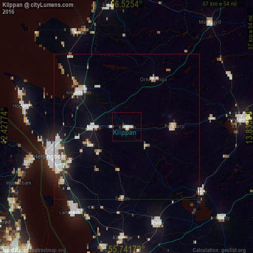
Analysis of Klippan night lights 2016
Square area 10x10 km:
 1.08%
1.08%90-99
1.32%80-89
0.48%70-79
0.96%60-69
0.48%50-59
0%40-49
0.48%30-39
0.48%20-29
0.12%10-19
0.36%0-9
94.26%Square area 50x50 km:
1.31%90-99
1.53%80-89
0.42%70-79
0.45%60-69
0.61%50-59
0.61%40-49
0.42%30-39
0.34%20-29
0.87%10-19
4.37%0-9
89.08%Clear (daylight) street map image can be seen on geolist.org.
Map coordinates:
56° 31' 31.4" North, 12° 25' 39.9" East
56° 8' 8.1" North, 13° 7' 51.1" East
55° 44' 30.4" North, 13° 50' 2.4" East
Some cities around Klippan sort by population:
• Helsingborg
28.8 km =17.9 mi,  249°
249°
• Ängelholm
20.5 km =12.7 mi,  305°
305°
• Bjuv
14.3 km =8.9 mi, 246°
• Åstorp
11.6 km =7.2 mi,  270°
270°
• Rydebäck
29.4 km =18.3 mi,  230°
230°
• Perstorp
16.4 km =10.2 mi,  88°
88°
• Ödåkra
24 km =14.9 mi,  261°
261°
• Örkelljunga
18.8 km =11.7 mi,  28°
28°
2700487 (p: 8,411)
Sources (retrieved 2019-11-25):
» Earth at Night: Flat Maps 2012, 2016