Bjuv night lights from space
Night Light of Bjuv (Skåne) from space (Sweden) Src. Average luminocity for 10x10km area is 18.311% and for 50x50km: 10.4251%.
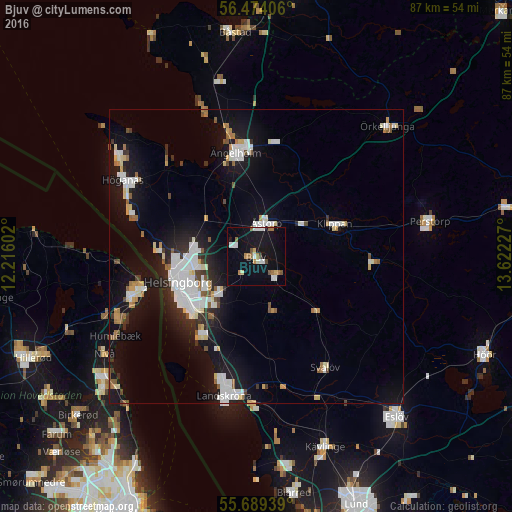
Analysis of Bjuv night lights 2016
Square area 10x10 km:
 3.23%
3.23%90-99
2.99%80-89
1.32%70-79
0.96%60-69
3.95%50-59
2.15%40-49
0.84%30-39
0.36%20-29
0%10-19
21.41%0-9
62.8%Square area 50x50 km:
2.4%90-99
2.27%80-89
0.83%70-79
0.68%60-69
0.96%50-59
0.87%40-49
0.63%30-39
0.77%20-29
1.81%10-19
9.53%0-9
79.25%Clear (daylight) street map image can be seen on geolist.org.
Map coordinates:
56° 28' 26.6" North, 12° 12' 57.7" East
56° 5' 1.4" North, 12° 55' 8.9" East
55° 41' 21.8" North, 13° 37' 20.2" East
Some cities around Bjuv sort by population:
• Helsingborg
14.5 km =9 mi,  253°
253°
• Helsingør, DK
19.7 km =12.2 mi, 254°
• Ängelholm
18 km =11.2 mi,  348°
348°
• Åstorp
6 km =3.7 mi,  15°
15°
• Klippan
14.3 km =8.9 mi,  66°
66°
• Rydebäck
16.1 km =10 mi,  216°
216°
• Hellebæk, DK
22.5 km =14 mi,  265°
265°
• Ödåkra
10.9 km =6.8 mi,  282°
282°
2721534 (p: 10,602)
Sources (retrieved 2019-11-25):
» Earth at Night: Flat Maps 2012, 2016