Al Fuwayliq night lights from space
Night Light of Al Fuwayliq (Al-Qassim) from space (Saudi Arabia) Src. Average luminocity for 10x10km area is 24.9091% and for 50x50km: 2.1677%.
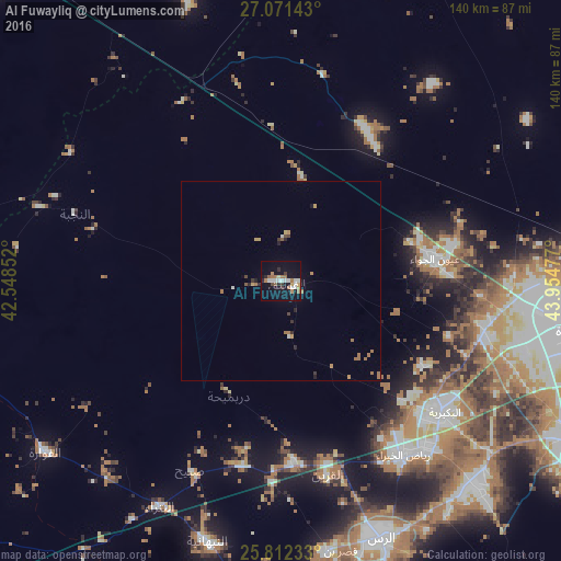
Analysis of Al Fuwayliq night lights 2016
Square area 10x10 km:
 4.55%
4.55%90-99
4.55%80-89
0.76%70-79
2.84%60-69
6.25%50-59
1.52%40-49
1.52%30-39
2.27%20-29
3.22%10-19
24.24%0-9
48.3%Square area 50x50 km:
0.22%90-99
0.24%80-89
0.08%70-79
0.38%60-69
0.69%50-59
0.19%40-49
0.17%30-39
0.23%20-29
0.35%10-19
1.11%0-9
96.33%Clear (daylight) street map image can be seen on geolist.org.
Map coordinates:
27° 4' 17.1" North, 42° 32' 54.7" East
26° 26' 37" North, 43° 15' 5.9" East
25° 48' 44.4" North, 43° 57' 17.2" East
Some cities around Al Fuwayliq sort by population:
• Buraydah
73.2 km =45.5 mi,  100°
100°
• Ar Rass
68.4 km =42.5 mi,  158°
158°
• Al Mithnab
116.6 km =72.5 mi,  123°
123°
• Az Zulfī
156.6 km =97.3 mi, 95°
• Al Bukayrīyah
52.8 km =32.8 mi,  129°
129°
• Adh Dhibiyah
47.3 km =29.4 mi,  191°
191°
• Tanūmah
114 km =70.8 mi,  50°
50°
• Sājir
194.6 km =120.9 mi,  136°
136°
397513 (p: 5,205)
Sources (retrieved 2019-11-25):
» Earth at Night: Flat Maps 2012, 2016