As Saffānīyah night lights from space
Night Light of As Saffānīyah (Eastern Province) from space (Saudi Arabia) Src. Average luminocity for 10x10km area is 30.7765% and for 50x50km: 5.7439%.
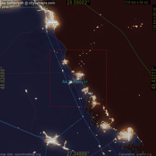
Analysis of As Saffānīyah night lights 2016
Square area 10x10 km:
 3.98%
3.98%90-99
3.03%80-89
1.33%70-79
5.68%60-69
9.66%50-59
4.73%40-49
3.03%30-39
5.11%20-29
6.25%10-19
24.81%0-9
32.39%Square area 50x50 km:
0.52%90-99
0.59%80-89
0.34%70-79
0.55%60-69
1.59%50-59
0.72%40-49
0.87%30-39
0.73%20-29
1.37%10-19
5.01%0-9
87.72%Clear (daylight) street map image can be seen on geolist.org.
Map coordinates:
28° 35' 24.1" North, 48° 1' 36.8" East
27° 58' 15" North, 48° 43' 48" East
27° 20' 53" North, 49° 25' 59.3" East
Some cities around As Saffānīyah sort by population:
• Al Aḩmadī, KW
138.2 km =85.9 mi,  332°
332°
• Al Jubayl
137.8 km =85.6 mi,  140°
140°
• Al Faḩāḩīl, KW
136.8 km =85 mi, 334°
• Al Khafjī
57.1 km =35.5 mi,  335°
335°
• Al Manqaf, KW
138.1 km =85.8 mi, 335°
• Al Mahbūlah, KW
143.1 km =88.9 mi, 335°
• Al Wafrah, KW
107.9 km =67 mi,  313°
313°
• Mulayjah
83.4 km =51.8 mi,  201°
201°
108142 (p: 7,014)
Sources (retrieved 2019-11-25):
» Earth at Night: Flat Maps 2012, 2016